IMAGES TAKEN NEAR TO
Bakewell Street, DERBY, DE22 3SB
Introduction
This page details the photographs taken nearby to Bakewell Street, DE22 3SB by members of the Geograph project.
The Geograph project started in 2005 with the aim of publishing, organising and preserving representative images for every square kilometre of Great Britain, Ireland and the Isle of Man.

There are currently over 7.5m images from over14,400 individuals and you can help contribute to the project by visiting https://www.geograph.org.uk
Image Map
Images are licensed for reuse under creativecommons.org/licenses/by-sa/2.0
Notes
- Clicking on the map will re-center to the selected point.
- The higher the marker number, the further away the image location is from the centre of the postcode.
Image Listing (144 Images Found)
Images are licensed for reuse under creativecommons.org/licenses/by-sa/2.0
Image
Details
Distance
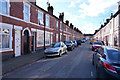
3
Inner City Derby
Back to back terraced housing in the inner city of Derby
Image: © Val Vannet
Taken: 29 Mar 2005
0.03 miles
4
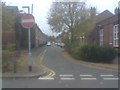
Jackson Street from Drewry Lane, Derby
Jackson Street taken from its junction with Drewry Lane.
Image: © Eamon Curry
Taken: 14 Oct 2007
0.04 miles
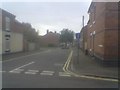
5
Lynton Street from Bakewell Street, Derby
Lynton Street taken from its junction with Bakewell Street.
Image: © Eamon Curry
Taken: 16 Oct 2007
0.04 miles
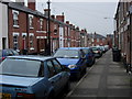
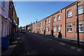
6
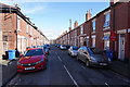
Wolfa Street Derby
Standing at the junction of Wolfa Street and Bakewell Street the image shows terraced houses on both sides along with an almost continuous line of parked cars on both sides.
Image: © Malcolm Neal
Taken: 25 Feb 2020
0.04 miles
7
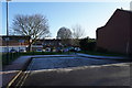
Jackson Street Derby
A bright cold morning with frost on the ground as we look across Jackson Street to an area where cars are parked.
Image: © Malcolm Neal
Taken: 21 Jan 2020
0.05 miles
8
Werburgh Street Derby
These are the houses at the end of Werburgh Street that is furthest away from the city centre and are close to the junction with Bakewell Street.
Image: © Malcolm Neal
Taken: 25 Feb 2020
0.05 miles
9
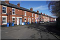
King Alfred Street
King Alfred Street is a street with terraced housing on both sides, with no possible off street parking.
Image: © Malcolm Neal
Taken: 25 Feb 2020
0.06 miles
10
Drewry Lane flats
This is a closer view of the old factory on Drewry Lane that has been converted to flats. The Factory was James Smith and Co. who manufactured clothing.
Image: © Malcolm Neal
Taken: 25 Feb 2020
0.07 miles