IMAGES TAKEN NEAR TO
Bedford Street, DERBY, DE22 3PD
Introduction
This page details the photographs taken nearby to Bedford Street, DE22 3PD by members of the Geograph project.
The Geograph project started in 2005 with the aim of publishing, organising and preserving representative images for every square kilometre of Great Britain, Ireland and the Isle of Man.

There are currently over 7.5m images from over14,400 individuals and you can help contribute to the project by visiting https://www.geograph.org.uk
Image Map
Images are licensed for reuse under creativecommons.org/licenses/by-sa/2.0
Notes
- Clicking on the map will re-center to the selected point.
- The higher the marker number, the further away the image location is from the centre of the postcode.
Image Listing (56 Images Found)
Images are licensed for reuse under creativecommons.org/licenses/by-sa/2.0
Image
Details
Distance
1

Abbey Lodge Student Village
Modern student accommodation on the site of the Derby College of Education.
Image: © Alan Murray-Rust
Taken: 19 Feb 2019
0.06 miles
2

Lonsdale Hall, Lonsdale Place
Built 1856 for William Bemrose, founder of the local printing firm, probably designed by T C Hine of Nottingham. It later became part of the Bishop Lonsdale College of Education, which eventually became part of the University of Derby. Now part of Abbey Lodge Student Village. Listed Grade II.
Image: © Alan Murray-Rust
Taken: 19 Feb 2019
0.08 miles
3

Lonsdale Hall, Lonsdale Place
Built 1856 for William Bemrose, founder of the local printing firm, probably designed by T C Hine of Nottingham. The left hand wing is a later addition dated 1890. It later became part of the Bishop Lonsdale College of Education, which eventually became part of the University of Derby. Now part of Abbey Lodge Student Village. Listed Grade II.
Image: © Alan Murray-Rust
Taken: 19 Feb 2019
0.09 miles
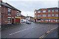
4
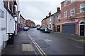
Stockbrook Road
Offset a little from the end of Stockbrook Street is Stockbrook Road. It is again composed of mainly terraced houses which have all been upgraded rather than redveloped by being pulled down as happened to much of Stockbrook Street in the 1970s.
Image: © Malcolm Neal
Taken: 3 Mar 2020
0.09 miles
5
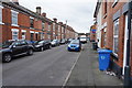
Leicester Street
It is obviously 'bin day' in this area as both the black waste and the blue recycling bins are out on the street awaiting collection.
Image: © Malcolm Neal
Taken: 11 Mar 2020
0.12 miles
6
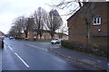
Amy Street
This view is looking along a very short Amy Street towards Upper Boundary Road. Visible are the newer houses but well beyond are the older red brick terraced houses of Upper Boundary Road.
Image: © Malcolm Neal
Taken: 3 Mar 2020
0.12 miles
7
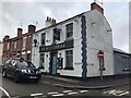
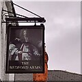
The Bedford Arms
Corner pub needing some new letters.
Image: © David Lally
Taken: 12 Nov 2021
0.12 miles
9
Stockbrook Street
The building at the very end of Stockbrook Street is called "The Recycle Shop" but as the shutters were down it was difficult to see what variety of recycling is carried out.
Image: © Malcolm Neal
Taken: 3 Mar 2020
0.13 miles
10
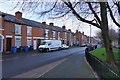
Upper Boundary Road
Having walked on from Amy Street we can now see the older terraced houses that form the far side of Upper Boundary Road. To the right is the grass area on the edge of the redeveloped housing which is also on Upper Boundary Road.
Image: © Malcolm Neal
Taken: 3 Mar 2020
0.14 miles