
IMAGES TAKEN NEAR TO
Milton Street, DERBY, DE22 3PA
Introduction
This page details the photographs taken nearby to Milton Street, DE22 3PA by members of the Geograph project.
The Geograph project started in 2005 with the aim of publishing, organising and preserving representative images for every square kilometre of Great Britain, Ireland and the Isle of Man.

There are currently over 7.5m images from over14,400 individuals and you can help contribute to the project by visiting https://www.geograph.org.uk
Image Map
Images are licensed for reuse under creativecommons.org/licenses/by-sa/2.0
Notes
- Clicking on the map will re-center to the selected point.
- The higher the marker number, the further away the image location is from the centre of the postcode.
Image Listing (111 Images Found)
Images are licensed for reuse under creativecommons.org/licenses/by-sa/2.0
Image
Details
Distance
1
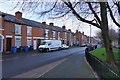
Upper Boundary Road
Having walked on from Amy Street we can now see the older terraced houses that form the far side of Upper Boundary Road. To the right is the grass area on the edge of the redeveloped housing which is also on Upper Boundary Road.
Image: © Malcolm Neal
Taken: 3 Mar 2020
0.03 miles
2
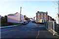
An offset road junction
The security fencing is along the wall of the cemetery and just beyond is the offset junction between Boundary Road, Camden Street, Drewry Lane and Upper Boundary Road.
Image: © Malcolm Neal
Taken: 21 Jan 2020
0.05 miles
3
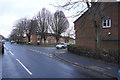
Amy Street
This view is looking along a very short Amy Street towards Upper Boundary Road. Visible are the newer houses but well beyond are the older red brick terraced houses of Upper Boundary Road.
Image: © Malcolm Neal
Taken: 3 Mar 2020
0.06 miles
5

Bench mark, Boundary Road
See http://www.geograph.org.uk/photo/6066815 for location.
Image: © Alan Murray-Rust
Taken: 19 Feb 2019
0.07 miles
6

Boundary Road corner of the Old Cemetery
Boundary Road marked the original mid 19th century boundary of the Borough.
There is a benchmark http://www.geograph.org.uk/photo/6066812 on the wall in line with the spire of the large building.
Image: © Alan Murray-Rust
Taken: 19 Feb 2019
0.07 miles
7
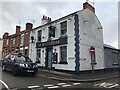
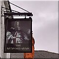
The Bedford Arms
Corner pub needing some new letters.
Image: © David Lally
Taken: 12 Nov 2021
0.07 miles
8

Derby Old Cemetery, Summers Memorial
Dating from c.1923 the style is in complete contrast to the more formal Victorian crosses and obelisks close by.
Image: © Alan Murray-Rust
Taken: 19 Feb 2019
0.08 miles
9
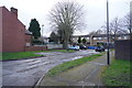
Freehold Street
Looking at the parking access area to the houses that border Upper Boundary Road from Freehold Street.
Image: © Malcolm Neal
Taken: 3 Mar 2020
0.09 miles
10
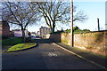
Drewry Lane
The footpath has now widened into more of a road, but it still borders the cemetery, one of whose memorials can be seen as the obelisk beyond the wall.
Image: © Malcolm Neal
Taken: 21 Jan 2020
0.09 miles