IMAGES TAKEN NEAR TO
Birchover Way, DERBY, DE22 2RR
Introduction
This page details the photographs taken nearby to Birchover Way, DE22 2RR by members of the Geograph project.
The Geograph project started in 2005 with the aim of publishing, organising and preserving representative images for every square kilometre of Great Britain, Ireland and the Isle of Man.

There are currently over 7.5m images from over14,400 individuals and you can help contribute to the project by visiting https://www.geograph.org.uk
Image Map
Images are licensed for reuse under creativecommons.org/licenses/by-sa/2.0
Notes
- Clicking on the map will re-center to the selected point.
- The higher the marker number, the further away the image location is from the centre of the postcode.
Image Listing (7 Images Found)
Images are licensed for reuse under creativecommons.org/licenses/by-sa/2.0
Image
Details
Distance
4
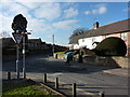
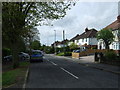
Cornhill and Robincroft Road, Allestree
Road junction in the Derby suburb.
Image: © Peter Barr
Taken: 28 Jan 2011
0.12 miles
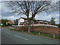
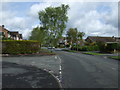
6
Highway Maintenance, Allestree
Meanwhile the old ladies and gentlemen at the Evergreen Club (opposite) were getting ready for morning coffee.
Image: © Peter Barr
Taken: 28 Jan 2011
0.23 miles