IMAGES TAKEN NEAR TO
Blenheim Drive, DERBY, DE22 2LH
Introduction
This page details the photographs taken nearby to Blenheim Drive, DE22 2LH by members of the Geograph project.
The Geograph project started in 2005 with the aim of publishing, organising and preserving representative images for every square kilometre of Great Britain, Ireland and the Isle of Man.

There are currently over 7.5m images from over14,400 individuals and you can help contribute to the project by visiting https://www.geograph.org.uk
Image Map
Images are licensed for reuse under creativecommons.org/licenses/by-sa/2.0
Notes
- Clicking on the map will re-center to the selected point.
- The higher the marker number, the further away the image location is from the centre of the postcode.
Image Listing (10 Images Found)
Images are licensed for reuse under creativecommons.org/licenses/by-sa/2.0
Image
Details
Distance
1
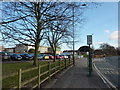
Bus stop at Woodlands School
The post by the bus stop has the number 12 displayed, to indicate how many minutes should elapse before the next bus. Derbyshire Council put these digital devices all along the A6 route of the Transpeak bus from Derby to Rowsley, at the cost of countless thousands of pounds; they didn't work !
Image: © Peter Barr
Taken: 28 Jan 2011
0.09 miles
2
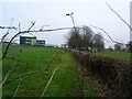
Old Lane
This part of an old lane into Allestree was closed off when the schools were built in the 1950s. However, the hollowed route is still clearly visible.
Image: © Ian Calderwood
Taken: 15 Feb 2017
0.09 miles
3
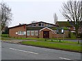
Holy Family Catholic Church
The parish of Holy Family was created in October 1970. The church/hall was dedicated in May 1972.
Image: © Ian Calderwood
Taken: 15 Feb 2017
0.11 miles
4

The new Allestree Woodlands School
I used to work here in the 1970's and 80's. These new buildings look far better than the ones we had to use then.
Image: © Malcolm Neal
Taken: 27 Apr 2017
0.14 miles
5
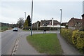
Askerfield Avenue
Askerfield Avenue joins Kedleston Road just ahead. It is the route into a newer part of Allestree in that the houses here have been erected for rather more than 50 years.
Image: © Malcolm Neal
Taken: 8 Mar 2021
0.21 miles
6
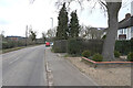
Kedleston Road
The brown sign to the left directs you towards Kedleston Hall, the National Trust property once the home of Lord Curzon. His descendants now live in part of the house.
Image: © Malcolm Neal
Taken: 8 Mar 2021
0.22 miles
7
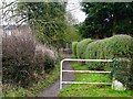
Bridleway to Allestree
On the 1836 Ordnance Survey First Series map, this is marked as a narrow lane leading into Allestree. Much of it has been obliterated by development and only a short length of bridleway is left.
Image: © Ian Calderwood
Taken: 15 Feb 2017
0.22 miles
8
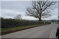
Kedleston Road
Walking along Kedleston Road towards Quarndon, ghowever we will turn to the left before we reach the satellite village and return to Derby through open countryside.
Image: © Malcolm Neal
Taken: 8 Mar 2021
0.23 miles
9
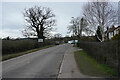
Kedleston Road
On the edge of Derby Kedleston Road soon turns to the left to run towards Kedleston Hall.
Image: © Malcolm Neal
Taken: 8 Mar 2021
0.23 miles
10
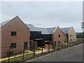
New housing development on the outskirts of Derby
Image: © Eirian Evans
Taken: 30 Jul 2022
0.24 miles