IMAGES TAKEN NEAR TO
Allestree Lane, DERBY, DE22 2HR
Introduction
This page details the photographs taken nearby to Allestree Lane, DE22 2HR by members of the Geograph project.
The Geograph project started in 2005 with the aim of publishing, organising and preserving representative images for every square kilometre of Great Britain, Ireland and the Isle of Man.

There are currently over 7.5m images from over14,400 individuals and you can help contribute to the project by visiting https://www.geograph.org.uk
Image Map
Images are licensed for reuse under creativecommons.org/licenses/by-sa/2.0
Notes
- Clicking on the map will re-center to the selected point.
- The higher the marker number, the further away the image location is from the centre of the postcode.
Image Listing (9 Images Found)
Images are licensed for reuse under creativecommons.org/licenses/by-sa/2.0
Image
Details
Distance
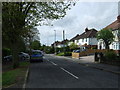
6
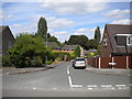
Lea Close, Allestree
Off Clifton Road.
Image: © Richard Vince
Taken: 11 Aug 2018
0.20 miles
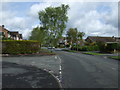
8
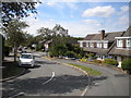
Descending Birchover Way, Allestree
Looking towards the older part of Allestree.
Image: © Richard Vince
Taken: 11 Aug 2018
0.24 miles
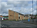
9
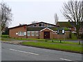
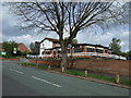
Holy Family Catholic Church
The parish of Holy Family was created in October 1970. The church/hall was dedicated in May 1972.
Image: © Ian Calderwood
Taken: 15 Feb 2017
0.25 miles