IMAGES TAKEN NEAR TO
West Bank Road, DERBY, DE22 2FZ
Introduction
This page details the photographs taken nearby to West Bank Road, DE22 2FZ by members of the Geograph project.
The Geograph project started in 2005 with the aim of publishing, organising and preserving representative images for every square kilometre of Great Britain, Ireland and the Isle of Man.

There are currently over 7.5m images from over14,400 individuals and you can help contribute to the project by visiting https://www.geograph.org.uk
Image Map
Images are licensed for reuse under creativecommons.org/licenses/by-sa/2.0
Notes
- Clicking on the map will re-center to the selected point.
- The higher the marker number, the further away the image location is from the centre of the postcode.
Image Listing (9 Images Found)
Images are licensed for reuse under creativecommons.org/licenses/by-sa/2.0
Image
Details
Distance
1
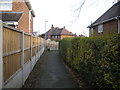
Footpath to Firs Crescent, Allestree
Off Woodlands Road.
Image: © Richard Vince
Taken: 7 Dec 2019
0.09 miles
2
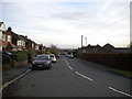
Top of West Bank Road, Allestree
Seen from close to the junction with Woodlands Road.
Image: © Richard Vince
Taken: 7 Dec 2019
0.10 miles
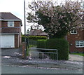
5

Fringes of Allestree Park and Nature Reserve
Park Entrance next to Woodlands Road.
Image: © Jonathan Clitheroe
Taken: 15 Feb 2014
0.12 miles

7

Path into Allestree Park
Off Woodlands Road.
Image: © JThomas
Taken: 26 Apr 2014
0.14 miles
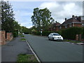
8

Woodlands Road north of Allestree
Heading past Allestree Park (right) towards Quarndon.
Image: © Richard Vince
Taken: 7 Dec 2019
0.15 miles
9
Allestree Park
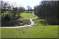
A walk around the perimeter of Allestree Park and golf course. The golf course is now closed so walking on it is fairly safe.
Image: © Malcolm Neal
Taken: 16 Mar 2021
0.24 miles