IMAGES TAKEN NEAR TO
Park Wood Close, DERBY, DE22 2AX
Introduction
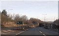
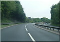
This page details the photographs taken nearby to Park Wood Close, DE22 2AX by members of the Geograph project.
The Geograph project started in 2005 with the aim of publishing, organising and preserving representative images for every square kilometre of Great Britain, Ireland and the Isle of Man.

There are currently over 7.5m images from over14,400 individuals and you can help contribute to the project by visiting https://www.geograph.org.uk
Image Map
Images are licensed for reuse under creativecommons.org/licenses/by-sa/2.0
Notes
- Clicking on the map will re-center to the selected point.
- The higher the marker number, the further away the image location is from the centre of the postcode.
Image Listing (17 Images Found)
Images are licensed for reuse under creativecommons.org/licenses/by-sa/2.0
Image
Details
Distance
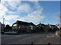
4
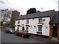
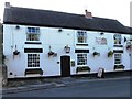
Church and Public House in Allestree Village
The Red Cow Public House and Church of St Edmund sited in a conservation area at the centre of the old village.
Image: © Jonathan Clitheroe
Taken: 15 Feb 2014
0.16 miles
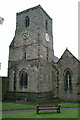
10
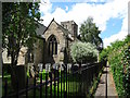
Church Walk
Church Walk has St. Edmund's Church at one end and a Methodist Chapel at the other.
Image: © Ian Calderwood
Taken: 14 Jul 2016
0.18 miles