
IMAGES TAKEN NEAR TO
Nottingham Road, DERBY, DE21 6HB
Introduction
This page details the photographs taken nearby to Nottingham Road, DE21 6HB by members of the Geograph project.
The Geograph project started in 2005 with the aim of publishing, organising and preserving representative images for every square kilometre of Great Britain, Ireland and the Isle of Man.

There are currently over 7.5m images from over14,400 individuals and you can help contribute to the project by visiting https://www.geograph.org.uk
Image Map
Images are licensed for reuse under creativecommons.org/licenses/by-sa/2.0
Notes
- Clicking on the map will re-center to the selected point.
- The higher the marker number, the further away the image location is from the centre of the postcode.
Image Listing (114 Images Found)
Images are licensed for reuse under creativecommons.org/licenses/by-sa/2.0
Image
Details
Distance

2

Howorth Timber and Building Merchants
Looking down from the footbridge into the store yard of the building merchants. This is one of two that stand across the road from each other on Nottingham Road.
Image: © Malcolm Neal
Taken: 21 May 2019
0.04 miles

4
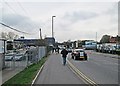
On Nottingham Road
Some spectators walking to the city centre after the second day of the Derbyshire-Nottinghamshire County Championship match. Before the building of the inner ring road, this was the A52, and until 1967 Nottingham Road railway station stood to the north of the bridge in the centre of the picture.
Image: © John Sutton
Taken: 25 Apr 2013
0.06 miles
5
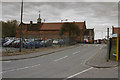
Street Pride Depot
This is the headquarters old Highways Department for Derby. Now it is called Street Pride but serves the same purpose. It is where I had my first summer job as a student way back in the late 1960's.
Image: © Malcolm Neal
Taken: 13 Apr 2017
0.06 miles
6
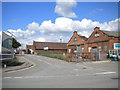
Derby City Council highways depot
Seen from Nottingham Road just east of the city centre.
Image: © Richard Vince
Taken: 7 Jul 2012
0.06 miles
7

A footbridge by the railway line
Another bridge in Derby that I didn't know existed until I started Geographing. The railway lines are immediately to the right of the footbridge.
Image: © Malcolm Neal
Taken: 21 May 2019
0.07 miles
8

Up freight entering Derby station, 1957
View northward from the platform ends, with Derby Station North signalbox on the left, Derby Goods box on the right. Very smart ex-Works Stanier 8F 2-8-0 No. 48188 (built 1943, withdrawn 5/66) heads the train, taking the Goods line passing the Station on the east side. Note the great display of semaphore signals.
Image: © Ben Brooksbank
Taken: 14 Jun 1957
0.07 miles
9

A cycle and footpath
Here it is much clearer who should be using which part of the path in Derby city centre.
Image: © Malcolm Neal
Taken: 20 Aug 2019
0.08 miles
10
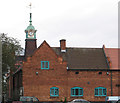
Derby - Stores Road depot clocktower
Familiar to rail users travelling north of Derby, the clock on this building has shown accurate time continuously for at least the last 15 years! The building is part of Derby City Council's Streetpride depot on Stores Road. This view is taken from the footbridge over the A52.
Image: © Dave Bevis
Taken: 21 Oct 2011
0.08 miles