IMAGES TAKEN NEAR TO
Sir Frank Whittle Road, DERBY, DE21 4XA
Introduction
This page details the photographs taken nearby to Sir Frank Whittle Road, DE21 4XA by members of the Geograph project.
The Geograph project started in 2005 with the aim of publishing, organising and preserving representative images for every square kilometre of Great Britain, Ireland and the Isle of Man.

There are currently over 7.5m images from over14,400 individuals and you can help contribute to the project by visiting https://www.geograph.org.uk
Image Map
Images are licensed for reuse under creativecommons.org/licenses/by-sa/2.0
Notes
- Clicking on the map will re-center to the selected point.
- The higher the marker number, the further away the image location is from the centre of the postcode.
Image Listing (91 Images Found)
Images are licensed for reuse under creativecommons.org/licenses/by-sa/2.0
Image
Details
Distance
1

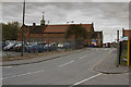
Derby : Sir Frank Whittle Road A61
Heading along the A61.
Image: © Lewis Clarke
Taken: 25 Sep 2020
0.02 miles
2
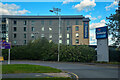
Derby : Travelodge Derby Cricket Ground
A Travelodge off Sir Frank Whittle Road.
Image: © Lewis Clarke
Taken: 25 Sep 2020
0.05 miles
3
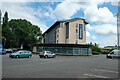
Travelodge, Derby Cricket Ground
Travelodge located at The County Ground, Nottingham Road in Derby.
Image: © Jeff Buck
Taken: 14 Jul 2022
0.08 miles
4
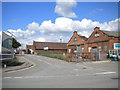
Derby City Council highways depot
Seen from Nottingham Road just east of the city centre.
Image: © Richard Vince
Taken: 7 Jul 2012
0.08 miles
5
The City Council Works Depot
This 100 metre square is in the middle of the council depot so I asked at the security office if I could take this image and was escorted with high vis jacket the few metres into the sub square so that I could get every one of the 100 metre sub squares in SK3536.
Image: © Malcolm Neal
Taken: 20 Aug 2019
0.09 miles
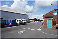
6
Street Pride Depot
This is the headquarters old Highways Department for Derby. Now it is called Street Pride but serves the same purpose. It is where I had my first summer job as a student way back in the late 1960's.
Image: © Malcolm Neal
Taken: 13 Apr 2017
0.10 miles
7

Enterprise Way
The building to the right is the MS Centre and others close by house a nursery and car parts businesses.
Image: © Malcolm Neal
Taken: 20 Aug 2019
0.11 miles
8
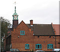
Derby - Stores Road depot clocktower
Familiar to rail users travelling north of Derby, the clock on this building has shown accurate time continuously for at least the last 15 years! The building is part of Derby City Council's Streetpride depot on Stores Road. This view is taken from the footbridge over the A52.
Image: © Dave Bevis
Taken: 21 Oct 2011
0.11 miles
9

Jubilee Parkway
Yet more small businesses that appear from how new everything is looking are relatively recent to this area.
Image: © Malcolm Neal
Taken: 20 Aug 2019
0.11 miles
10
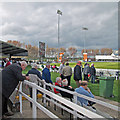
Derby: the tea interval at the County Ground
Tea and talk on a cloudy afternoon.
Image: © John Sutton
Taken: 24 Apr 2013
0.11 miles