IMAGES TAKEN NEAR TO
Stanton Road, BURTON-ON-TRENT, DE15 9SQ
Introduction
This page details the photographs taken nearby to Stanton Road, DE15 9SQ by members of the Geograph project.
The Geograph project started in 2005 with the aim of publishing, organising and preserving representative images for every square kilometre of Great Britain, Ireland and the Isle of Man.

There are currently over 7.5m images from over14,400 individuals and you can help contribute to the project by visiting https://www.geograph.org.uk
Image Map
Images are licensed for reuse under creativecommons.org/licenses/by-sa/2.0
Notes
- Clicking on the map will re-center to the selected point.
- The higher the marker number, the further away the image location is from the centre of the postcode.
Image Listing (7 Images Found)
Images are licensed for reuse under creativecommons.org/licenses/by-sa/2.0
Image
Details
Distance
1
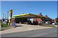
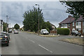
Service station on Stanton Road (A444), Stanton
Image: © JThomas
Taken: 27 Jun 2019
0.11 miles
2
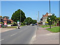
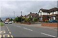
Stanton Road (A444), Stanton
Towards Burton upon Trent.
Image: © JThomas
Taken: 27 Jun 2019
0.11 miles
3
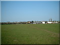
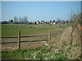
A distant A444
The A444 in the distance with a set of farm buildings in the field
Image: © Mark Walton
Taken: 1 Apr 2007
0.14 miles
4
Nearly at Stanton
Stapenhill runs into Stanton and this is the road that connects the two together.
Image: © Malcolm Neal
Taken: 9 Aug 2018
0.15 miles
6
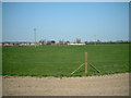
Horse paddocks abound
100yards into Bridle lane there is an abrupt turn in a Southward direction to the right heading North is a footpath which crosses a number of horse paddocks until it reaches the A444.
Image: © Mark Walton
Taken: 1 Apr 2007
0.18 miles