IMAGES TAKEN NEAR TO
Cumberland Road, BURTON-ON-TRENT, DE15 9JP
Introduction
This page details the photographs taken nearby to Cumberland Road, DE15 9JP by members of the Geograph project.
The Geograph project started in 2005 with the aim of publishing, organising and preserving representative images for every square kilometre of Great Britain, Ireland and the Isle of Man.

There are currently over 7.5m images from over14,400 individuals and you can help contribute to the project by visiting https://www.geograph.org.uk
Image Map
Images are licensed for reuse under creativecommons.org/licenses/by-sa/2.0
Notes
- Clicking on the map will re-center to the selected point.
- The higher the marker number, the further away the image location is from the centre of the postcode.
Image Listing (4 Images Found)
Images are licensed for reuse under creativecommons.org/licenses/by-sa/2.0
Image
Details
Distance
1
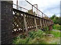
Rusty footbridge over the railway
Formerly carrying a field path but now connecting two housing estates.
Image: © Ian Calderwood
Taken: 18 Jul 2019
0.20 miles
2

Replacement footbridge over the railway
Since Image was taken in 2019, the old footbridge has been replaced with this new one. As well as being in better condition, this bridge is more accessible. The embankment in the foreground has been extended outward, across the redundant former Drakelow Power Station line, so that the new bridge, as well as being shorter, is served by a gradually sloping path, instead of the set of stairs that served the old one.
Image: © Ian Calderwood
Taken: 20 Jan 2022
0.21 miles