1
St. Joseph the Worker
A Catholic Chapel of Ease in the former Winshill Institute building.
Image: © Ian Calderwood
Taken: 1 Aug 2020
0.08 miles
2
Ashby Road in Burton upon Trent
The road is descending towards the River Trent.
Image: © Mat Fascione
Taken: 21 Jun 2015
0.15 miles
3
Milestone, Ashby Road, Burton
Erected for the Ashby to Tutbury Turnpike, probably early 19th century but possibly earlier. See http://www.geograph.org.uk/photo/4003568 for location. Currently there is some confusion as to whether this is a Listed structure. English Heritage have a milepost of which the description matches this, but located on Burton Bridge where there is also a cast milestone, but not matching the description http://www.geograph.org.uk/photo/4003556. It could refer to one or the other, or perhaps the intention is that both should be listed.
Image: © Alan Murray-Rust
Taken: 25 May 2014
0.15 miles
4
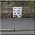
Old Milepost by the A511, Ashby Road, Winshill
South Derbyshire iron plate by the A511 (was A50), in parish of Burton upon Trent (East Staffordshire District), Ashby Road, Winshill, by No. 29, below junction with Mervyn Road, in stone wall of garden.
Inscription reads:-
LONDON
124 MILES
ASHBY
8 MILES
BURTON
1 MILE
Grade II listed.
List Entry Number: 1392728 https://historicengland.org.uk/listing/the-list/list-entry/1392728
Surveyed
Milestone Society National ID: ST_BTAZ01
Image: © Alan Rosevear
Taken: 25 Nov 2004
0.15 miles
5
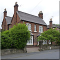
House on Ashby Road, with milestone
Taken principally to locate the milestone shown in this picture http://www.geograph.org.uk/photo/4003567
Image: © Alan Murray-Rust
Taken: 25 May 2014
0.15 miles
6
Old Milestone, A511
Winshill Burton upon Trent. North side of Ashby Road. South Derbyshire iron plate, erected by the Ashby de la Zouch to Tutbury turnpike trust in the 19th century.
Inscription reads: LONDON / 124 MILES / ASHBY / 8 MILES / BURTON / 2 MILE
Milestone Society National ID: DE_BTAZ01
Image: © Ivan Clare
Taken: 18 Oct 2021
0.16 miles
7
Winshill Milestone
On Ashby Road.
Image: © David Rogers
Taken: 15 May 2009
0.16 miles
8
The Winshill milestone
Embedded fairly securely into the front wall of a house on the A511 Ashby Road.
Image: © Richard Law
Taken: 22 May 2013
0.16 miles
9
The A511 at Winshill
On the long climb up from the Trent valley onto Winshill towards Swadlincote. The small white square object embedded in the wall 5 yards behind the pickup is the Winshill milestone
Image and
Image
Image: © Richard Law
Taken: 22 May 2013
0.16 miles
10
The Anglesey Arms
Described by Marston's as a "traditional wet only venue with a strong cask ale offer and regular weekly schedule of events including games, bingo, quiz and auctions".
Image: © Ian Calderwood
Taken: 1 Aug 2020
0.16 miles


