IMAGES TAKEN NEAR TO
Elm Close, BURTON-ON-TRENT, DE14 3NH
Introduction
This page details the photographs taken nearby to Elm Close, DE14 3NH by members of the Geograph project.
The Geograph project started in 2005 with the aim of publishing, organising and preserving representative images for every square kilometre of Great Britain, Ireland and the Isle of Man.

There are currently over 7.5m images from over14,400 individuals and you can help contribute to the project by visiting https://www.geograph.org.uk
Image Map
Images are licensed for reuse under creativecommons.org/licenses/by-sa/2.0
Notes
- Clicking on the map will re-center to the selected point.
- The higher the marker number, the further away the image location is from the centre of the postcode.
Image Listing (5 Images Found)
Images are licensed for reuse under creativecommons.org/licenses/by-sa/2.0
Image
Details
Distance
1
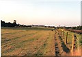
Branston pasture and Burton skyline
"Crazy Horse Field" at Branston, with a touch of the Burton skyline visible. The tower on the left of the picture is the Bass, (now Coors), Maltings tower. The whole of this area alongside the railway has now been subjected to housing development.
Image: © Chris Eaton
Taken: 24 Jul 1990
0.10 miles
2
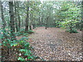
Agger of Ryknild Street Roman Road
Agger of Roman road passing through Bean's Covert.
Image: © Lez Watson
Taken: 2 Nov 2014
0.13 miles
3
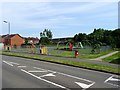
Regents Park Play Area
The play area and outdoor gym was opened on Thursday 10th March 2016 by the Mayor of East Staffordshire.
Image: © Ian Calderwood
Taken: 4 Jul 2019
0.17 miles