
IMAGES TAKEN NEAR TO
Cotswold Road, BURTON-ON-TRENT, DE14 3JQ
Introduction
This page details the photographs taken nearby to Cotswold Road, DE14 3JQ by members of the Geograph project.
The Geograph project started in 2005 with the aim of publishing, organising and preserving representative images for every square kilometre of Great Britain, Ireland and the Isle of Man.

There are currently over 7.5m images from over14,400 individuals and you can help contribute to the project by visiting https://www.geograph.org.uk
Image Map
Images are licensed for reuse under creativecommons.org/licenses/by-sa/2.0
Notes
- Clicking on the map will re-center to the selected point.
- The higher the marker number, the further away the image location is from the centre of the postcode.
Image Listing (8 Images Found)
Images are licensed for reuse under creativecommons.org/licenses/by-sa/2.0
Image
Details
Distance
1
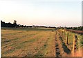
Branston pasture and Burton skyline
"Crazy Horse Field" at Branston, with a touch of the Burton skyline visible. The tower on the left of the picture is the Bass, (now Coors), Maltings tower. The whole of this area alongside the railway has now been subjected to housing development.
Image: © Chris Eaton
Taken: 24 Jul 1990
0.07 miles
2
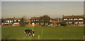
Housing at Branston
Semis on Bridgford Avenue seen across a rectangular pasture, with what looks rather like a two-headed cow grazing (at one end). I suppose you could say that a pair of animals have got themselves in a pickle.
Taken from a train which has just passed Branston Junction, hence the reflected light on a window.
Image: © Derek Harper
Taken: 6 Apr 2012
0.12 miles
3
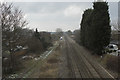
Looking towards Burton
The railway line to Burton runs to Lichfield Birmingham and the National Exhibition Centre.
Image: © Malcolm Neal
Taken: 28 Feb 2018
0.13 miles
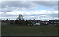
5
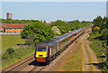
Train at Branston
Express passenger train at Branston on the outskirts of Burton on Trent.
Image: © Wayland Smith
Taken: 2 May 2011
0.16 miles
6
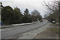
Rising over the bridge
The Burton Road here is gently rising to pass over the railway line from Burton. Once over the bridge the road changes its name yet again to Main Street.
Image: © Malcolm Neal
Taken: 28 Feb 2018
0.20 miles
7
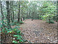
Agger of Ryknild Street Roman Road
Agger of Roman road passing through Bean's Covert.
Image: © Lez Watson
Taken: 2 Nov 2014
0.23 miles
8
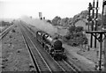
Bristol -Sheffield express passing remains of Branston station
View SW, towards Tamworth, Birmingham etc.: ex-Midland Derby - Birmingham - Bristol main line. The Up express is headed by Stanier 5MT 4-6-0 No. 45346 (built 1937, withdrawn 6/67). The station had been closed since 9/30 - see Image
Image: © Ben Brooksbank
Taken: 4 Jun 1962
0.24 miles