IMAGES TAKEN NEAR TO
Montpelier Close, BURTON-ON-TRENT, DE14 3GB
Introduction
This page details the photographs taken nearby to Montpelier Close, DE14 3GB by members of the Geograph project.
The Geograph project started in 2005 with the aim of publishing, organising and preserving representative images for every square kilometre of Great Britain, Ireland and the Isle of Man.

There are currently over 7.5m images from over14,400 individuals and you can help contribute to the project by visiting https://www.geograph.org.uk
Image Map
Images are licensed for reuse under creativecommons.org/licenses/by-sa/2.0
Notes
- Clicking on the map will re-center to the selected point.
- The higher the marker number, the further away the image location is from the centre of the postcode.
Image Listing (12 Images Found)
Images are licensed for reuse under creativecommons.org/licenses/by-sa/2.0
Image
Details
Distance
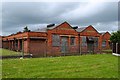
1
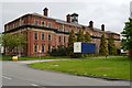
National Machine Gun Factory - Offices
Grade II listed building.
Image: © John M
Taken: 21 May 2016
0.10 miles
2
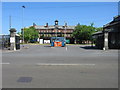
Branston Depot - the original home of Branston Pickle
Branston Depot is situated on Burton Road, Branston, Burton upon Trent, Staffordshire. It was built in 1915 as the National Machine Gun Factory and was then taken over by Crosse and Blackwell in the 1920s, with the village giving its name to the world famous pickle that was first produced there. In the 1930s it became a silk factory and was taken over by the Army in the Second World War as their Central Ordnance Depot. They remained there until the 1960s, when it then became Home Office stores, supplying prisons and storing the former AFS 'Green Goddess' fire engines. The 'Green Goddesses', which were used by the military during national firefighters' strikes, moved to a store at nearby Marchington at the end of the 1980s. In 2004, part of the Depot was leased to B&Q and is operated as a distribution depot for them by the logistics firm TNT. A massive fire at the beginning of 2006, destroyed millions of pounds worth of fitted kitchens stock and the warehouse centred on SK23552162.
Image: © Alan Slater
Taken: 24 Jul 2006
0.11 miles
3
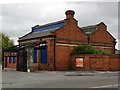
National Machine Gun Factory - Gatehouse
The large factory is surrounded by brick perimeter walls apparently built by German prisoners of war.
Image: © John M
Taken: 21 May 2016
0.15 miles
4
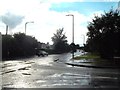
A Passing Heavy Shower in Branston
This is the corner of Regents Park Road and Burton Road in the Branston area of Burton.
Image: © Jonathan Clitheroe
Taken: 1 Sep 2015
0.16 miles
5
National Machine Gun Factory - Canteen
It is perhaps surprising the amount of effort expended on the appearance of these factory buildings and the contrast with the utilitarian structures in WW2.
Image: © John M
Taken: 21 May 2016
0.16 miles
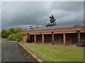
6
National Machine Gun Factory - Canteen
The canteen building is one of the original listed buildings on the site. There are plans to retain these for retail use when the site is redeveloped for housing.
Image: © John M
Taken: 21 May 2016
0.19 miles
7
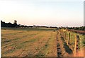
Branston pasture and Burton skyline
"Crazy Horse Field" at Branston, with a touch of the Burton skyline visible. The tower on the left of the picture is the Bass, (now Coors), Maltings tower. The whole of this area alongside the railway has now been subjected to housing development.
Image: © Chris Eaton
Taken: 24 Jul 1990
0.19 miles
8
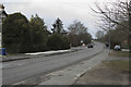
Rising over the bridge
The Burton Road here is gently rising to pass over the railway line from Burton. Once over the bridge the road changes its name yet again to Main Street.
Image: © Malcolm Neal
Taken: 28 Feb 2018
0.22 miles
9
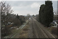
Looking towards Burton
The railway line to Burton runs to Lichfield Birmingham and the National Exhibition Centre.
Image: © Malcolm Neal
Taken: 28 Feb 2018
0.22 miles
10
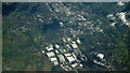
Burton Upon Trent from the air
Looking east over the town from a Luton bound flight from Glasgow.
Image: © Thomas Nugent
Taken: 17 Apr 2024
0.23 miles