IMAGES TAKEN NEAR TO
The Lawns, BURTON-ON-TRENT, DE13 9DD
Introduction
This page details the photographs taken nearby to The Lawns, DE13 9DD by members of the Geograph project.
The Geograph project started in 2005 with the aim of publishing, organising and preserving representative images for every square kilometre of Great Britain, Ireland and the Isle of Man.

There are currently over 7.5m images from over14,400 individuals and you can help contribute to the project by visiting https://www.geograph.org.uk
Image Map
Images are licensed for reuse under creativecommons.org/licenses/by-sa/2.0
Notes
- Clicking on the map will re-center to the selected point.
- The higher the marker number, the further away the image location is from the centre of the postcode.
Image Listing (76 Images Found)
Images are licensed for reuse under creativecommons.org/licenses/by-sa/2.0
Image
Details
Distance
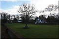
1
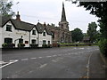
Spread Eagle and St Mary's
The church in Rolleston on Dove is dedicated to St Mary. The Spread Eagle pub next door shares some of its architecture with many railway buildings.
Image: © Michael Patterson
Taken: 6 Jul 2006
0.05 miles
2
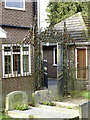
Churchyard railings and gate
On the west side of the churchyard. The gate now leads into a private house, but probably originally formed the private access to the church from Rolleston Hall. Dating from around 1800 and Listed Grade II.
Image: © Alan Murray-Rust
Taken: 21 Feb 2014
0.06 miles
3
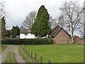
Tudor House and Church Room
The school house dates from the 17th century, although modified in the 19th century. The house (whitewashed) is a later addition. The school was replaced by a national school for the village towards the end of the 19th century and is now the church rooms.
Image: © Alan Murray-Rust
Taken: 21 Feb 2014
0.06 miles
4
Church Room, formerly School House
The school house dates from the 17th century, although modified in the 19th century. Listed Grade II. The school was replaced by a national school for the village towards the end of the 19th century and is now the church rooms. The left hand extension is modern.
Image: © Alan Murray-Rust
Taken: 21 Feb 2014
0.06 miles
5
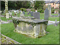
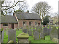
Tomb of George Ridgway, Rolleston churchyard
Chest tomb of 1824, Listed Grade II.
Image: © Alan Murray-Rust
Taken: 21 Feb 2014
0.07 miles
7
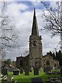
Church of St Mary, Rolleston
View from the west. A feature of the tower is the offset bell-chamber opening, making room for staircase. The spire and south aisle are late Victorian additions. Listed Grade I.
Image: © Alan Murray-Rust
Taken: 21 Feb 2014
0.08 miles
8
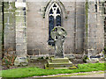
Medieval cross, Rolleston
The precise date of the cross is unknown although it is of Anglo-Scandinavian style, predominantly found from the 8th to 10th centuries. It is unusual in retaining the complete cross head and part of the shaft. The base is modern, from the end of the 19th century. Scheduled Monument.
Image: © Alan Murray-Rust
Taken: 21 Feb 2014
0.08 miles
10
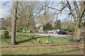
St. Mary's Church Rolleston on Dove
A brook just visible at the bottom right is between the road and the land that surrounds the parish church of St. Mary.
Image: © Malcolm Neal
Taken: 14 Apr 2018
0.08 miles