IMAGES TAKEN NEAR TO
Burrows Walk, DERBY, DE1 2PL
Introduction
This page details the photographs taken nearby to Burrows Walk, DE1 2PL by members of the Geograph project.
The Geograph project started in 2005 with the aim of publishing, organising and preserving representative images for every square kilometre of Great Britain, Ireland and the Isle of Man.

There are currently over 7.5m images from over14,400 individuals and you can help contribute to the project by visiting https://www.geograph.org.uk
Image Map
Images are licensed for reuse under creativecommons.org/licenses/by-sa/2.0
Notes
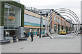
- Clicking on the map will re-center to the selected point.
- The higher the marker number, the further away the image location is from the centre of the postcode.
Image Listing (425 Images Found)
Images are licensed for reuse under creativecommons.org/licenses/by-sa/2.0
Image
Details
Distance
1
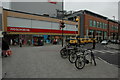
Woolworths in Derby
The former Woolworths store in Derby.
Image: © Philip Halling
Taken: 27 Jun 2009
0.01 miles
3
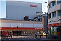
The Westfield Centre
The uncompromising architecture of the Westfield Centre, which opened in October 2007.
Image: © Jerry Evans
Taken: 7 Mar 2008
0.03 miles
4
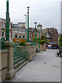
The Spot, Derby
The area was remodelled in the 1990s, retaining the Art Deco features.
Image: © Alan Murray-Rust
Taken: 14 Aug 2013
0.04 miles
5
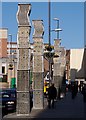
Vertical Gardens, The Spot, Derby
These newly installed sculptures by John Packer are planted with native wildflowers and are supposed to provide wildlife habitat in the centre of Derby. They are part of the Westfield Centre public art programme.
Image: © Jerry Evans
Taken: 7 Mar 2008
0.04 miles
6
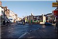
The Spot
The junction where Osmaston Road and London Road converge into St Peter's Street is a well-known Derby landmark. The former Eagle Centre, now subsumed into the Westfield Centre is to the right.
Image: © Jerry Evans
Taken: 7 Mar 2008
0.04 miles
8
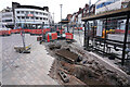
A hole in the ground
This is the redevelopment of the raod and pavement in Dreby City Centre. The hole is where the underground public toilets used to be, which were closed at least 15 years ago. Also visible is what may be a tram line in the lower centre of the image, showing where the road used to run, many, many years ago.
Image: © Malcolm Neal
Taken: 23 Aug 2023
0.04 miles
9
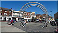
Art in Derby city centre
The four partial rings were commissioned by the previous Labour Administration and were supposedly cost free to the city but the bill was rather larger than zero. The Ram statue in the entrance to the Intu centre is fairly new, having only been there a matter of weeks and is causing some interest for passers by.
Image: © Malcolm Neal
Taken: 27 Mar 2019
0.04 miles
10
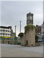
Spot the Clock
More correctly, Clock, The Spot. An imposing example of civic decorative architecture in Art Deco style at the entry to the centre of the city on the old London Road.
The origin of the name of the location, The Spot, has never been satisfactorily explained.
Image: © Alan Murray-Rust
Taken: 14 Aug 2013
0.05 miles