
IMAGES TAKEN NEAR TO
Bramble Street, DERBY, DE1 1HU
Introduction
This page details the photographs taken nearby to Bramble Street, DE1 1HU by members of the Geograph project.
The Geograph project started in 2005 with the aim of publishing, organising and preserving representative images for every square kilometre of Great Britain, Ireland and the Isle of Man.

There are currently over 7.5m images from over14,400 individuals and you can help contribute to the project by visiting https://www.geograph.org.uk
Image Map
Images are licensed for reuse under creativecommons.org/licenses/by-sa/2.0
Notes
- Clicking on the map will re-center to the selected point.
- The higher the marker number, the further away the image location is from the centre of the postcode.
Image Listing (559 Images Found)
Images are licensed for reuse under creativecommons.org/licenses/by-sa/2.0
Image
Details
Distance
1
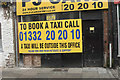
Check your spelling
This notice has been outside the burnt out remains of a taxi firm since it was attacked around Christmas time. We pass the sign at least twice a week but yesterday I read the sign and noticed the error.
Image: © Malcolm Neal
Taken: 8 Feb 2018
0.02 miles
2

Derby - City Church
On Curzon Street. For an alternative view, please see Alan Murray-Rust's Image
Image: © Dave Bevis
Taken: 18 Dec 2012
0.03 miles
3
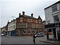
The Lord Nelson
At the junction of Friar Gate and Curzon Street, Derby, a pub named after our naval hero, now some sort of music club.
Image: © Peter Barr
Taken: 24 Mar 2010
0.03 miles
4

Former education offices, Becket Street, Derby
An impressive palazzo, built as the Poor Law Guardians Office, by Giles & Brookhouse 1864-69, and enlarged by Ernest Ryley, 1890-93. The latter date appears at the top of the main front. Grade II listed.
Its last incarnation appears to have been as a nightclub, Aruba, but was empty and boarded up at the time.
Image: © Stephen Richards
Taken: 20 Jun 2012
0.03 miles
5

Derby City Church
An evangelical Christian group now occupies the original Temperance Hall. The main building dates from 1854, designed by Henry I Stevens. It became a dance hall in the 1950s before passing to the Elim Pentecostal Church. Listed Grade II.
Image: © Alan Murray-Rust
Taken: 3 Apr 2011
0.03 miles
6

Curzon Street, Derby
Derby City Church near the junction with Friar Gate.
Image: © David Hallam-Jones
Taken: 15 Nov 2014
0.03 miles
7
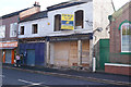
Renovations in hand
The shop front has been removed to show one of the older uses for this building. In my teens it was an Art Shop selling paitnings and artists materials but clearly before that it was a reupholsterers.
Image: © Malcolm Neal
Taken: 8 Oct 2019
0.03 miles
8
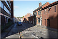
Newland Street
The building on the left used to be called the Derby labour Exchange but it is now known as Forester House. The building to the right is the Drill Hall Vaults a public house with a large room for events and gatherings.
Image: © Malcolm Neal
Taken: 8 Oct 2019
0.04 miles
9

Forester House, Newland Street, Derby
Post-war office block housing a job centre.
Image: © Stephen Richards
Taken: 20 Jun 2012
0.04 miles
10

The Lord Nelson Public House
A public house of some age on the corner of The Wardwick and Curzon Street. It has recently reverted to its original name.
Image: © Malcolm Neal
Taken: 18 Mar 2017
0.05 miles