IMAGES TAKEN NEAR TO
Ninelands Mobile Home Park, Elmsdale Road, SWADLINCOTE, DE11 7HP
Introduction
This page details the photographs taken nearby to Ninelands Mobile Home Park, Elmsdale Road, DE11 7HP by members of the Geograph project.
The Geograph project started in 2005 with the aim of publishing, organising and preserving representative images for every square kilometre of Great Britain, Ireland and the Isle of Man.

There are currently over 7.5m images from over14,400 individuals and you can help contribute to the project by visiting https://www.geograph.org.uk
Image Map
Images are licensed for reuse under creativecommons.org/licenses/by-sa/2.0
Notes
- Clicking on the map will re-center to the selected point.
- The higher the marker number, the further away the image location is from the centre of the postcode.
Image Listing (4 Images Found)
Images are licensed for reuse under creativecommons.org/licenses/by-sa/2.0
Image
Details
Distance

2
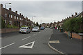
Brookdale Road
A typical road of semi-detached houses just on the very edge of Woodville. The name sign for the village is a few yards further along the main road, so the houses may not be properly in this village.
Image: © Malcolm Neal
Taken: 11 Oct 2017
0.20 miles
3
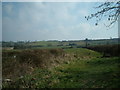
Footpath to Boundary
The public footpath follows the field boundary denoted by the hedge on the right hand side of the photograph. It runs all the way up the hill to the A511 at a place called Boundary.
Image: © Mark Walton
Taken: 25 Mar 2007
0.21 miles
4
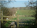
Footpath to Goseley Dale
The footpath follows the hedge line into the distance to Goseley Dale and eventually Hartshorne
Image: © Mark Walton
Taken: 25 Mar 2007
0.23 miles