IMAGES TAKEN NEAR TO
Wainwright Drive, SWADLINCOTE, DE11 7FF
Introduction
This page details the photographs taken nearby to Wainwright Drive, DE11 7FF by members of the Geograph project.
The Geograph project started in 2005 with the aim of publishing, organising and preserving representative images for every square kilometre of Great Britain, Ireland and the Isle of Man.

There are currently over 7.5m images from over14,400 individuals and you can help contribute to the project by visiting https://www.geograph.org.uk
Image Map
Images are licensed for reuse under creativecommons.org/licenses/by-sa/2.0
Notes
- Clicking on the map will re-center to the selected point.
- The higher the marker number, the further away the image location is from the centre of the postcode.
Image Listing (6 Images Found)
Images are licensed for reuse under creativecommons.org/licenses/by-sa/2.0
Image
Details
Distance
1
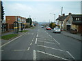
A514 Woodville
Looking out from Woodville, North eastly straight down the centre of the road (A514). The Industrial units and shops giving way to residential housing after about 150 yards.
Image: © Mark Walton
Taken: 25 Mar 2007
0.14 miles
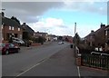
3
The edge of Woodville
Woodville is one of several villages in this area named after raw materials, Iron and Coal are other similarly named villages. The whole area is a former mining area but the mines are long gone.
Image: © Malcolm Neal
Taken: 11 Oct 2017
0.20 miles
4
Goseley Avenue in Woodville
The local convenience store can be seen in the centre of picture.
Image: © Jonathan Clitheroe
Taken: 4 Mar 2015
0.21 miles
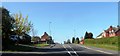
5
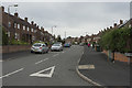
Brookdale Road
A typical road of semi-detached houses just on the very edge of Woodville. The name sign for the village is a few yards further along the main road, so the houses may not be properly in this village.
Image: © Malcolm Neal
Taken: 11 Oct 2017
0.23 miles
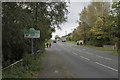
6
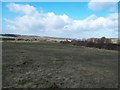
Fields near Broomy Furlong
Paddocks and livery stables with an appropriately equine-sounding name situated close to Lower Midway and Woodville.
Image: © Jonathan Clitheroe
Taken: 4 Mar 2015
0.23 miles