IMAGES TAKEN NEAR TO
Jade Close, SWADLINCOTE, DE11 0XR
Introduction
This page details the photographs taken nearby to Jade Close, DE11 0XR by members of the Geograph project.
The Geograph project started in 2005 with the aim of publishing, organising and preserving representative images for every square kilometre of Great Britain, Ireland and the Isle of Man.

There are currently over 7.5m images from over14,400 individuals and you can help contribute to the project by visiting https://www.geograph.org.uk
Image Map
Images are licensed for reuse under creativecommons.org/licenses/by-sa/2.0
Notes
- Clicking on the map will re-center to the selected point.
- The higher the marker number, the further away the image location is from the centre of the postcode.
Image Listing (5 Images Found)
Images are licensed for reuse under creativecommons.org/licenses/by-sa/2.0
Image
Details
Distance
1
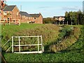
Balancing pond at Cadley Village
Flood alleviation at the new housing estate on the edge of Swadlincote.
Image: © Ian Calderwood
Taken: 25 Oct 2021
0.06 miles
2
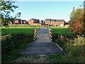
New footpath and footbridge at Cadley Village
As part of the Cadley Village housing development, some of the old footpaths in the area have been diverted and upgraded to all-weather surfaces.
Image: © Ian Calderwood
Taken: 25 Oct 2021
0.07 miles
3
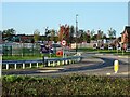
New road and construction site at Cadley Village
Cadley Village is a substantial development of new houses on the edge of Swadlincote.
Image: © Ian Calderwood
Taken: 25 Oct 2021
0.09 miles
4
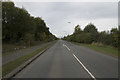
William Nadin Way
To the left of this fairly new wide road is a large industrial estate.
Image: © Malcolm Neal
Taken: 11 Oct 2017
0.09 miles
5
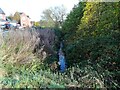
Darklands Brook
Photographed from a new footpath crossing for the new houses being built on the north side of the brook.
Image: © Ian Calderwood
Taken: 2 Nov 2021
0.23 miles