IMAGES TAKEN NEAR TO
Bramblewood, SWADLINCOTE, DE11 0TQ
Introduction
This page details the photographs taken nearby to Bramblewood, DE11 0TQ by members of the Geograph project.
The Geograph project started in 2005 with the aim of publishing, organising and preserving representative images for every square kilometre of Great Britain, Ireland and the Isle of Man.

There are currently over 7.5m images from over14,400 individuals and you can help contribute to the project by visiting https://www.geograph.org.uk
Image Map
Images are licensed for reuse under creativecommons.org/licenses/by-sa/2.0
Notes
- Clicking on the map will re-center to the selected point.
- The higher the marker number, the further away the image location is from the centre of the postcode.
Image Listing (2 Images Found)
Images are licensed for reuse under creativecommons.org/licenses/by-sa/2.0
Image
Details
Distance
1
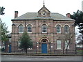
Newhall Memorial
This was built in 1874 by the Countess of Chesterfield in Memory of her only son George the 7th Earl of Chesterfield
Image: © Paul Gilliver
Taken: 22 Mar 2006
0.24 miles
2
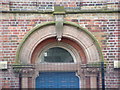
The Memorial Hall Doorway
Here is the inscription above the doorway of the Memorial Hall.
At on time it used to be part of The Newhall Junior School. It is now part of the South Derbyshire Social Service Offices
Image: © Paul Gilliver
Taken: 22 Mar 2006
0.25 miles