IMAGES TAKEN NEAR TO
Glenesk, BRECHIN, DD9 7YY
Introduction
This page details the photographs taken nearby to DD9 7YY by members of the Geograph project.
The Geograph project started in 2005 with the aim of publishing, organising and preserving representative images for every square kilometre of Great Britain, Ireland and the Isle of Man.

There are currently over 7.5m images from over14,400 individuals and you can help contribute to the project by visiting https://www.geograph.org.uk
Image Map
Images are licensed for reuse under creativecommons.org/licenses/by-sa/2.0
Notes
- Clicking on the map will re-center to the selected point.
- The higher the marker number, the further away the image location is from the centre of the postcode.
Image Listing (6 Images Found)
Images are licensed for reuse under creativecommons.org/licenses/by-sa/2.0
Image
Details
Distance
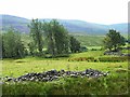
1
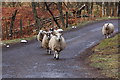
Glen Esk sheep making a break for freedom!
Image: © Roger Davies
Taken: 7 Apr 2012
0.10 miles
2
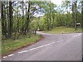
Road junction of the road to Dalbrack
Image: © Kevin Raistrick
Taken: 28 May 2006
0.11 miles
5
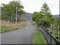
The Glen Esk road
The undulating minor road up Glen Esk near West Migvie.
Image: © Scott Cormie
Taken: 14 May 2017
0.22 miles