IMAGES TAKEN NEAR TO
Glenesk, BRECHIN, DD9 7YN
Introduction
This page details the photographs taken nearby to DD9 7YN by members of the Geograph project.
The Geograph project started in 2005 with the aim of publishing, organising and preserving representative images for every square kilometre of Great Britain, Ireland and the Isle of Man.

There are currently over 7.5m images from over14,400 individuals and you can help contribute to the project by visiting https://www.geograph.org.uk
Image Map (Loading...)


Getting Data...Please wait
Leaflet Map data © OpenStreetMap
Images are licensed for reuse under creativecommons.org/licenses/by-sa/2.0
Notes
- Clicking on the map will re-center to the selected point.
- The higher the marker number, the further away the image location is from the centre of the postcode.
Image Listing (15 Images Found)
Images are licensed for reuse under creativecommons.org/licenses/by-sa/2.0
Image
Details
Distance
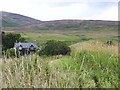
1
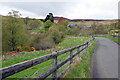
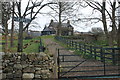
Auchmull Farm
Taken from across the burn by the farm
Image: © Dominic Dawn Harry and Jacob Paterson
Taken: 23 Nov 2005
0.03 miles
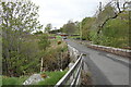
2
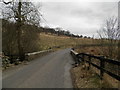
Bridge over Burn of Auchmull
The Burn of Auchmull flows into the North Esk a short distance to the south west.
Image: © Douglas Nelson
Taken: 19 Mar 2016
0.06 miles
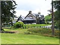
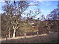
8
Auchmull
Country house on the north side of Glenesk.
Image: © Oliver Dixon
Taken: 8 Aug 2013
0.10 miles