IMAGES TAKEN NEAR TO
Edzell, BRECHIN, DD9 7UH
Introduction
This page details the photographs taken nearby to DD9 7UH by members of the Geograph project.
The Geograph project started in 2005 with the aim of publishing, organising and preserving representative images for every square kilometre of Great Britain, Ireland and the Isle of Man.

There are currently over 7.5m images from over14,400 individuals and you can help contribute to the project by visiting https://www.geograph.org.uk
Image Map
Images are licensed for reuse under creativecommons.org/licenses/by-sa/2.0
Notes
- Clicking on the map will re-center to the selected point.
- The higher the marker number, the further away the image location is from the centre of the postcode.
Image Listing (7 Images Found)
Images are licensed for reuse under creativecommons.org/licenses/by-sa/2.0
Image
Details
Distance
2
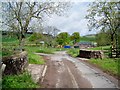
Burnfoot Cottage
It appears this cottage which used to be hidden in a forest of ivy is getting renovated.
Image: © Dominic Dawn Harry and Jacob Paterson
Taken: 15 Nov 2005
0.06 miles
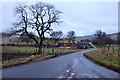
4

Brown and White Caterthuns sign
Sign pointing the way to the Caterthuns at the junction near Burnfoot.
Image: © Scott Cormie
Taken: 3 Aug 2017
0.08 miles
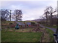
6
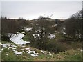
Flood plain, West Water
Having left the Mounth, West Water crosses lower hills on the Strathmore side of the Highland Boundary Fault. This is a small alder wood where the river takes a braided course in times of spate.
Image: © Richard Webb
Taken: 9 Feb 2013
0.15 miles
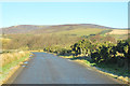
7
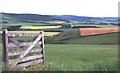
Glen Lethnot
Mixed farmland in the foothills of the Grampian Mountains
Image: © Anne Burgess
Taken: Unknown
0.22 miles