IMAGES TAKEN NEAR TO
Lethnot, Edzell, BRECHIN, DD9 7UF
Introduction
This page details the photographs taken nearby to DD9 7UF by members of the Geograph project.
The Geograph project started in 2005 with the aim of publishing, organising and preserving representative images for every square kilometre of Great Britain, Ireland and the Isle of Man.

There are currently over 7.5m images from over14,400 individuals and you can help contribute to the project by visiting https://www.geograph.org.uk
Image Map (Loading...)


Getting Data...Please wait
Leaflet Map data © OpenStreetMap
Images are licensed for reuse under creativecommons.org/licenses/by-sa/2.0
Notes
- Clicking on the map will re-center to the selected point.
- The higher the marker number, the further away the image location is from the centre of the postcode.
Image Listing (3 Images Found)
Images are licensed for reuse under creativecommons.org/licenses/by-sa/2.0
Image
Details
Distance
1
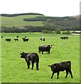
Cattle country, Tillydovie
Livestock farm on the edge of the hill country.
Image: © Gordon Hatton
Taken: 12 Sep 2021
0.10 miles
2
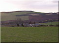
Tillydovie Farm
Image: © Dominic Dawn Harry and Jacob Paterson
Taken: 15 Nov 2005
0.18 miles
3
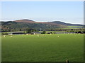
Tillydovie from the north
The farm buildings at Tillydovie viewed across a field of sheep, with the Caterthuns beyond.
Image: © Scott Cormie
Taken: 12 May 2019
0.19 miles