IMAGES TAKEN NEAR TO
The Glebe, BRECHIN, DD9 7SZ
Introduction
This page details the photographs taken nearby to The Glebe, DD9 7SZ by members of the Geograph project.
The Geograph project started in 2005 with the aim of publishing, organising and preserving representative images for every square kilometre of Great Britain, Ireland and the Isle of Man.

There are currently over 7.5m images from over14,400 individuals and you can help contribute to the project by visiting https://www.geograph.org.uk
Image Map
Images are licensed for reuse under creativecommons.org/licenses/by-sa/2.0
Notes
- Clicking on the map will re-center to the selected point.
- The higher the marker number, the further away the image location is from the centre of the postcode.
Image Listing (75 Images Found)
Images are licensed for reuse under creativecommons.org/licenses/by-sa/2.0
Image
Details
Distance
1
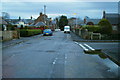
Manse Road, Edzell near its junction with Dalhousie Street
Image: © Alan Morrison
Taken: 16 Feb 2009
0.05 miles
2
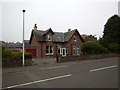
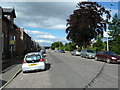
Edzell - Dalhousie Street
Detached house.
Image: © James Emmans
Taken: 15 Sep 2016
0.08 miles
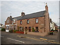
3
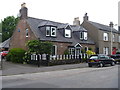
High Street cottage
The appeal of this delightful cottage in enhanced by the painted railings.
Image: © Michael Dibb
Taken: 16 Jun 2016
0.10 miles
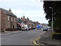
5
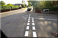
Dunlappie Road, Edzell at Dalhousie Street junction
Image: © Alan Morrison
Taken: 8 Oct 2008
0.11 miles
7
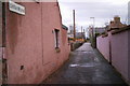
Little Wynd, Edzell
Photo taken from its junction with Church Street
Image: © Alan Morrison
Taken: 16 Feb 2009
0.11 miles
8
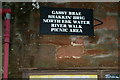
Signpost on south wall of Edzell Post Office
Image: © Alan Morrison
Taken: 16 Feb 2009
0.12 miles
9
Edzell - High Street
Old stone houses built with natural mined stone. This is known as rubble walling.
Image: © James Emmans
Taken: 14 Sep 2016
0.12 miles
10
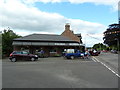
Cafe on the corner of Dunlappie Road and High Street, Edzell
Image: © Alexander P Kapp
Taken: 5 Sep 2012
0.12 miles