IMAGES TAKEN NEAR TO
BRECHIN, DD9 7RS
Introduction
This page details the photographs taken nearby to DD9 7RS by members of the Geograph project.
The Geograph project started in 2005 with the aim of publishing, organising and preserving representative images for every square kilometre of Great Britain, Ireland and the Isle of Man.

There are currently over 7.5m images from over14,400 individuals and you can help contribute to the project by visiting https://www.geograph.org.uk
Image Map
Images are licensed for reuse under creativecommons.org/licenses/by-sa/2.0
Notes
- Clicking on the map will re-center to the selected point.
- The higher the marker number, the further away the image location is from the centre of the postcode.
Image Listing (9 Images Found)
Images are licensed for reuse under creativecommons.org/licenses/by-sa/2.0
Image
Details
Distance
1
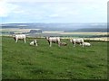
Young white bulls at Shandford
The broad vale of Strathmore beyond.
Image: © Oliver Dixon
Taken: 9 Aug 2013
0.16 miles
3

Approach to Shandford
On the minor road from the east.
Image: © Stanley Howe
Taken: 28 Jul 2016
0.17 miles
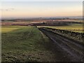
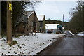
4
Road passing Shandford Farm
Looking north-eastward.
Image: © Peter Wood
Taken: 12 Oct 2019
0.18 miles
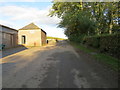
5
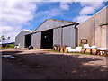
Shandford Farm buildings
By minor road to Fern.
Image: © Stanley Howe
Taken: 28 Jul 2016
0.19 miles
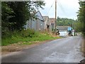
7
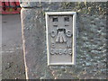
Ordnance Survey Flush Bracket G4648
This bracket can be found on the roadside wall of a building at Shandford Farm. The benchmark's recorded height is 167.76 metres above sea level.
For more detail see : https://www.bench-marks.org.uk/bm11800
Image: © Peter Wood
Taken: 12 Oct 2019
0.20 miles
8
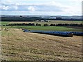
Bales in black, Shandford
Black covered bales stretch as far as the eye can see.
Image: © Maigheach-gheal
Taken: 7 Oct 2009
0.23 miles