IMAGES TAKEN NEAR TO
Menmuir, BRECHIN, DD9 7RG
Introduction
This page details the photographs taken nearby to DD9 7RG by members of the Geograph project.
The Geograph project started in 2005 with the aim of publishing, organising and preserving representative images for every square kilometre of Great Britain, Ireland and the Isle of Man.

There are currently over 7.5m images from over14,400 individuals and you can help contribute to the project by visiting https://www.geograph.org.uk
Image Map
Images are licensed for reuse under creativecommons.org/licenses/by-sa/2.0
Notes
- Clicking on the map will re-center to the selected point.
- The higher the marker number, the further away the image location is from the centre of the postcode.
Image Listing (10 Images Found)
Images are licensed for reuse under creativecommons.org/licenses/by-sa/2.0
Image
Details
Distance
2
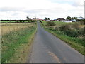
Minor road approaching Balrownie
Looking north-eastward.
Image: © Peter Wood
Taken: 12 Oct 2019
0.10 miles
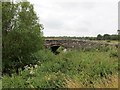
3
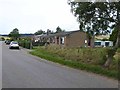
Mill of Balrownie
Image: © Dominic Dawn Harry and Jacob Paterson
Taken: 27 Jan 2006
0.11 miles
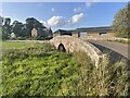
4
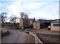
Mill of Balrownie
The Mill of Balrownie viewed from the road to the south.
Image: © Scott Cormie
Taken: 30 Sep 2018
0.13 miles
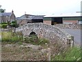
7
Bridge over Cruick Water at Mill of Balrownie
Image: © John Ferguson
Taken: 1 Aug 2018
0.17 miles
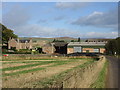
8
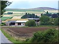
Farm buildings at Mill of Balrownie
Brown Caterthun Image with its hill fort stands on the horizon.
Image: © Oliver Dixon
Taken: 9 Aug 2013
0.19 miles
9
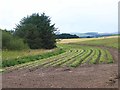
Harvested field of cabbages at Balrownie
Image: © Oliver Dixon
Taken: 9 Aug 2013
0.22 miles
10
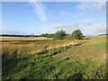
Bogland at Balrownie
Area of boggy land at the Buttery Burn near Balrownie.
Image: © Scott Cormie
Taken: 30 Sep 2018
0.23 miles