IMAGES TAKEN NEAR TO
BRECHIN, DD9 7QP
Introduction
This page details the photographs taken nearby to DD9 7QP by members of the Geograph project.
The Geograph project started in 2005 with the aim of publishing, organising and preserving representative images for every square kilometre of Great Britain, Ireland and the Isle of Man.

There are currently over 7.5m images from over14,400 individuals and you can help contribute to the project by visiting https://www.geograph.org.uk
Image Map
Images are licensed for reuse under creativecommons.org/licenses/by-sa/2.0
Notes
- Clicking on the map will re-center to the selected point.
- The higher the marker number, the further away the image location is from the centre of the postcode.
Image Listing (13 Images Found)
Images are licensed for reuse under creativecommons.org/licenses/by-sa/2.0
Image
Details
Distance
1
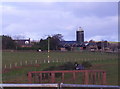
Kilgarie Farm
Image: © Dominic Dawn Harry and Jacob Paterson
Taken: 15 Nov 2005
0.02 miles
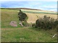
2
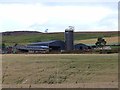
Kilgarie Farm
Brown Caterthun Image and its hill fort on the skyline.
Image: © Oliver Dixon
Taken: 10 Aug 2013
0.02 miles
3
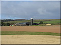
Kilgarie Farm
Kilgarie Farm, on the lower slopes of the Brown Caterthun, with its prominent silo in the centre of the picture.
Image: © Scott Cormie
Taken: 30 Sep 2018
0.02 miles
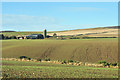
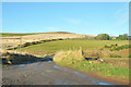
5

Donaldson Den
Between Wellsden and Kilgarie (in background)
Image: © Stanley Howe
Taken: 28 Jul 2016
0.12 miles
7

Kilgarie Farm sign
At its access from a minor Road near Wellsden Farm.
Image: © Stanley Howe
Taken: 28 Jul 2016
0.16 miles
8
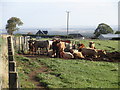
Feeding cattle
Cattle feeding at the roadside near Wellsden.
Image: © Scott Cormie
Taken: 30 Sep 2018
0.21 miles
10
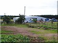
Irrigation equipment at Wellsden Farm
Image: © Oliver Dixon
Taken: 10 Aug 2013
0.23 miles