IMAGES TAKEN NEAR TO
Trinity, BRECHIN, DD9 7NT
Introduction
This page details the photographs taken nearby to DD9 7NT by members of the Geograph project.
The Geograph project started in 2005 with the aim of publishing, organising and preserving representative images for every square kilometre of Great Britain, Ireland and the Isle of Man.

There are currently over 7.5m images from over14,400 individuals and you can help contribute to the project by visiting https://www.geograph.org.uk
Image Map (Loading...)


Getting Data...Please wait
Leaflet Map data © OpenStreetMap
Images are licensed for reuse under creativecommons.org/licenses/by-sa/2.0
Notes
- Clicking on the map will re-center to the selected point.
- The higher the marker number, the further away the image location is from the centre of the postcode.
Image Listing (14 Images Found)
Images are licensed for reuse under creativecommons.org/licenses/by-sa/2.0
Image
Details
Distance
1
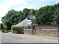
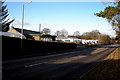
Road junction in Trinity
Approaching Brechin from Edzell.
Image: © Stanley Howe
Taken: 31 Jul 2007
0.06 miles
2
Little Kethock Farmhouse, near Brechin
Image: © Mike Pennington
Taken: 8 Jun 2015
0.08 miles
3
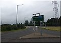
Access to A90 southbound
From the B966 by Temple Hill underpass.
Image: © Stanley Howe
Taken: 11 Jul 2015
0.09 miles
5
View of Trinity Garden and Caravan Centre, Brechin
Image: © Alan Morrison
Taken: 10 Feb 2010
0.14 miles
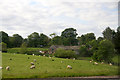
6
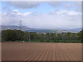
Ridges and Furrows near Brechin
This view is taken from the A90 looking north to the Grampians. The pylons, which can be seen on the OS map, help to fix position. The field in the foreground has recently been planted with potatoes.
Image: © Val Vannet
Taken: 9 May 2005
0.15 miles
7
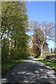
Tree Lined Road
The tree lined road to Templewood near Brecin.
Image: © Andrew Wood
Taken: 12 May 2010
0.17 miles
8
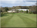
Brechin 1st hole, Taranty Market
The first hole at Brechin Golf Course looking down the hill to the green.
Image: © Scott Cormie
Taken: 21 Apr 2017
0.21 miles
9
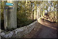
Brechin Path Network signpost near Trinity Village
Photograph taken from near the north end of Trinity Village, looking east.
Image: © Alan Morrison
Taken: 10 Feb 2010
0.21 miles
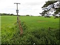
10

Farmland and power lines, Little Keithcock
Image: © JThomas
Taken: 20 Aug 2020
0.22 miles