1
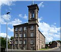
Montrose Street, Brechin at Denburn
Denburn Works was a factory but is now Flats
Image: © Alan Morrison
Taken: 30 Nov 2008
0.04 miles
2
Montrose Street (A935), Brechin
Image: © Elliott Simpson
Taken: 4 Aug 2015
0.04 miles
3
Junction of A935 with Witchden Road, Brechin
The former Denburn Works with tower (now residential flats) ahead.
Image: © Stanley Howe
Taken: 11 Jul 2015
0.05 miles
4
Witchden, Brechin at Montrose Street junction
Image: © Alan Morrison
Taken: 30 Nov 2008
0.06 miles
5
Flats on Montrose Street (A935), Brechin
Formerly the Denburn Works.
Image: © Stanley Howe
Taken: 11 Jul 2015
0.07 miles
6
Former Den Burn Works, Brechin
The B-listed (LB22513 https://portal.historicenvironment.scot/designation/LB22513 ) linen mill dates from 1864 and is now nicely converted into flats.
Image: © Bill Harrison
Taken: 11 Aug 2023
0.07 miles
7
View of the Old Denburn Works from Union Street
The Works were built in 1854 and the site was redeveloped into mixed use by Hillcrest in 1992. The mill and Italianate bell tower are listed.
Image: © James Emmans
Taken: 15 Sep 2016
0.08 miles
8
South Esk Street, Brechin
Image: © Alan Morrison
Taken: 30 Nov 2008
0.09 miles
9
Brechin Station and Yard
View westward, towards buffer-stops; ex-Caledonian terminus of branch from Bridge of Dun, also from Forfar via Careston and from Edzell. Services from Edzell had ceased on 27/9/38, those Forfar and from Bridge of Dun on 4/8/52 and the station was closed to passengers, but the lines from Careston survived until 17/3/58 and from Edzell until 7/9/64, but local freight continued to Brechin until 4/5/81. Since then the Heritage Caledonian Steam Railway (Brechin) has reopened the line to Bridge of Dun.
Image: © Ben Brooksbank
Taken: 21 Sep 1974
0.09 miles
10
A print-shop on South Esk Street (A935), Brechin
At the junction with Commerce Street. These premises were previously a licensed club (The City Club, a 'Tenants Brewery' house).
Image: © Stanley Howe
Taken: 11 Jul 2015
0.10 miles


