IMAGES TAKEN NEAR TO
Drumachlie Park, BRECHIN, DD9 7BT
Introduction
This page details the photographs taken nearby to Drumachlie Park, DD9 7BT by members of the Geograph project.
The Geograph project started in 2005 with the aim of publishing, organising and preserving representative images for every square kilometre of Great Britain, Ireland and the Isle of Man.

There are currently over 7.5m images from over14,400 individuals and you can help contribute to the project by visiting https://www.geograph.org.uk
Image Map (6 Images)


Leaflet Map data © OpenStreetMap
Images are licensed for reuse under creativecommons.org/licenses/by-sa/2.0
Notes
- Clicking on the map will re-center to the selected point.
- The higher the marker number, the further away the image location is from the centre of the postcode.
Image Listing (6 Images Found)
Images are licensed for reuse under creativecommons.org/licenses/by-sa/2.0
Image
Details
Distance
1
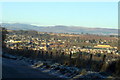
View of Brechin from Hillhead of Burghill Road
Image: © Alan Morrison
Taken: 30 Nov 2008
0.06 miles
3
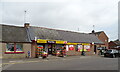
Post Office and convenience store on Montrose Street, Brechin
Image: © JThomas
Taken: 20 Jul 2021
0.10 miles
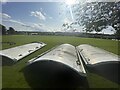
4
Thomas The Tank Engine crossing Drumachlie Loan Bridge, Brechin
Image: © Alan Morrison
Taken: 30 Aug 2007
0.15 miles
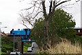
5
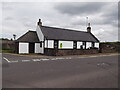
Former tollhouse
Surveyed by the Milestone Society. This former tollhouse on the A935 out of Brechin towards Montrose is called Leuchland Toll but also named East Toll House on the OS 50 000. There is a plaque on the wall with some of its history.
Image: © Chris Minto
Taken: 16 May 2014
0.17 miles
6
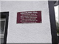
Former tollhouse
Surveyed by the Milestone Society. The plaque on Leuchland Tollhouse giving a brief history of the building.
Image: © Chris Minto
Taken: 16 May 2014
0.17 miles