IMAGES TAKEN NEAR TO
Wards Road, BRECHIN, DD9 7AS
Introduction
This page details the photographs taken nearby to Wards Road, DD9 7AS by members of the Geograph project.
The Geograph project started in 2005 with the aim of publishing, organising and preserving representative images for every square kilometre of Great Britain, Ireland and the Isle of Man.

There are currently over 7.5m images from over14,400 individuals and you can help contribute to the project by visiting https://www.geograph.org.uk
Image Map (Loading...)


Getting Data...Please wait
Leaflet Map data © OpenStreetMap
Images are licensed for reuse under creativecommons.org/licenses/by-sa/2.0
Notes
- Clicking on the map will re-center to the selected point.
- The higher the marker number, the further away the image location is from the centre of the postcode.
Image Listing (7 Images Found)
Images are licensed for reuse under creativecommons.org/licenses/by-sa/2.0
Image
Details
Distance
1
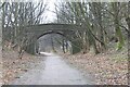
Railway Bridge
Bridge crossing the old railway line used for goods and distillery in Brechin
Image: © Mary Rodgers
Taken: 8 Jan 2024
0.12 miles
2

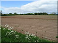
Glencadam Distillery
Brechin's distillery (http://www.glencadamdistillery.co.uk/ ) is sited between the football ground and the disused Brechin-Forfar railway.
Image: © TB
Taken: 19 Jan 2008
0.12 miles
6
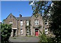
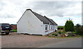
St Drostan's House, Infirmary Street, Brechin
Part of the former Brechin Infirmary and likely to be demolished. Note the jungle-like plant growing inside the window to the left of the red door.
Image: © Bill Harrison
Taken: 11 Aug 2023
0.21 miles