IMAGES TAKEN NEAR TO
BRECHIN, DD9 6TW
Introduction
This page details the photographs taken nearby to DD9 6TW by members of the Geograph project.
The Geograph project started in 2005 with the aim of publishing, organising and preserving representative images for every square kilometre of Great Britain, Ireland and the Isle of Man.

There are currently over 7.5m images from over14,400 individuals and you can help contribute to the project by visiting https://www.geograph.org.uk
Image Map
Images are licensed for reuse under creativecommons.org/licenses/by-sa/2.0
Notes
- Clicking on the map will re-center to the selected point.
- The higher the marker number, the further away the image location is from the centre of the postcode.
Image Listing (8 Images Found)
Images are licensed for reuse under creativecommons.org/licenses/by-sa/2.0
Image
Details
Distance
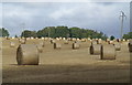
1
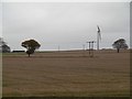
Stubble south of Brechin
The wind turbine is being installed.
Image: © Richard Webb
Taken: 11 Nov 2015
0.05 miles
2
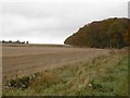
Stubble and Maules Wood
West side of the A933.
Image: © Richard Webb
Taken: 11 Nov 2015
0.07 miles
3
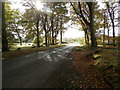
Minor road on edge of Maules Wood
Towards its junction with the A933
Image: © Douglas Nelson
Taken: 20 Oct 2016
0.10 miles
4
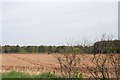
Fields by New Forebank
Cultivated fields amid woodland belts.
Image: © Andrew Wood
Taken: 25 Apr 2011
0.11 miles
5
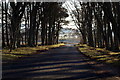
Burghill / Brechin / Arbroath junction
Image: © Alan Morrison
Taken: 30 Nov 2008
0.15 miles
7
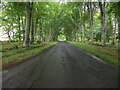
Road passing through Maules Wood
Looking northward.
Image: © Peter Wood
Taken: 10 Aug 2021
0.16 miles
