IMAGES TAKEN NEAR TO
Craigend Terrace, BRECHIN, DD9 6SS
Introduction
This page details the photographs taken nearby to Craigend Terrace, DD9 6SS by members of the Geograph project.
The Geograph project started in 2005 with the aim of publishing, organising and preserving representative images for every square kilometre of Great Britain, Ireland and the Isle of Man.

There are currently over 7.5m images from over14,400 individuals and you can help contribute to the project by visiting https://www.geograph.org.uk
Image Map
Images are licensed for reuse under creativecommons.org/licenses/by-sa/2.0
Notes
- Clicking on the map will re-center to the selected point.
- The higher the marker number, the further away the image location is from the centre of the postcode.
Image Listing (5 Images Found)
Images are licensed for reuse under creativecommons.org/licenses/by-sa/2.0
Image
Details
Distance
1
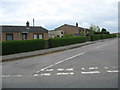
Bungalows on the junction
At Craigend near the Mains of Aldbar in Angus.
Image: © James Denham
Taken: 1 Jun 2010
0.03 miles
2
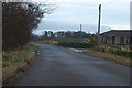
Pitkennedy / Brechin / West Drums road junction
Image: © Alan Morrison
Taken: 18 Jan 2009
0.06 miles
3
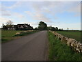
Craigend of Aldbar Road
Looking southwards down the minor road near the Craigend of Aldbar.
Image: © Scott Cormie
Taken: 15 May 2020
0.10 miles
4
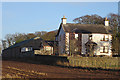
Craigend
The house at Craigend, with steading beyond.
Image: © Anne Burgess
Taken: 25 Jan 2018
0.10 miles
5
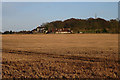
Field near Aldbar
Beyond the field are the cottages and farm house at Craigend, and the antenna of the Brechin Earth Station is on the skyline.
Image: © Anne Burgess
Taken: 25 Jan 2018
0.21 miles