IMAGES TAKEN NEAR TO
BRECHIN, DD9 6SJ
Introduction
This page details the photographs taken nearby to DD9 6SJ by members of the Geograph project.
The Geograph project started in 2005 with the aim of publishing, organising and preserving representative images for every square kilometre of Great Britain, Ireland and the Isle of Man.

There are currently over 7.5m images from over14,400 individuals and you can help contribute to the project by visiting https://www.geograph.org.uk
Image Map
Images are licensed for reuse under creativecommons.org/licenses/by-sa/2.0
Notes
- Clicking on the map will re-center to the selected point.
- The higher the marker number, the further away the image location is from the centre of the postcode.
Image Listing (15 Images Found)
Images are licensed for reuse under creativecommons.org/licenses/by-sa/2.0
Image
Details
Distance
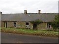
1
Entrance to Aldbar Castle
Aldbar Castle was a 16th century four-storey tower house. There may have been a fire and ultimately the building was demolished in 1965.
Image: © Alan Morrison
Taken: 27 Aug 2007
0.03 miles
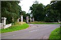
2
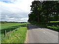
B9134, Aldbar
Brechin to Forfar road, via Aberlemno.
Image: © Richard Webb
Taken: 23 Jan 2016
0.04 miles
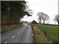
3
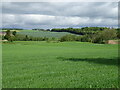
Broomknowe
A gloomy afternoon beside the South Esk. It was raining not far to the west.
Image: © Richard Webb
Taken: 23 Jan 2016
0.04 miles
7
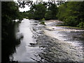
Aldbar Weir
Looking along the weir. Photograph taken from on top of the sluice gate for the lade leading to Blaikie Mill.
Image: © Karen Vernon
Taken: 2 Aug 2008
0.19 miles
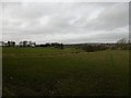
9
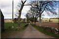
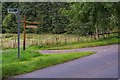
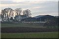
Broomknowe Farm
The approach to Broomknowe Farm by a tree lined road.
Image: © Andrew Wood
Taken: 17 Apr 2010
0.21 miles