IMAGES TAKEN NEAR TO
BRECHIN, DD9 6RZ
Introduction
This page details the photographs taken nearby to DD9 6RZ by members of the Geograph project.
The Geograph project started in 2005 with the aim of publishing, organising and preserving representative images for every square kilometre of Great Britain, Ireland and the Isle of Man.

There are currently over 7.5m images from over14,400 individuals and you can help contribute to the project by visiting https://www.geograph.org.uk
Image Map
Images are licensed for reuse under creativecommons.org/licenses/by-sa/2.0
Notes
- Clicking on the map will re-center to the selected point.
- The higher the marker number, the further away the image location is from the centre of the postcode.
Image Listing (16 Images Found)
Images are licensed for reuse under creativecommons.org/licenses/by-sa/2.0
Image
Details
Distance
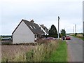
3
Lochty Council Houses near to Muir of Montboy
Looking eastward.
Image: © Peter Wood
Taken: 12 Oct 2019
0.03 miles
4
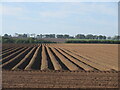
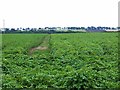
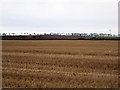
Furrowed field near Montboy
Looking southwards over a newly furrowed field at the Muir of Montboy.
Image: © Scott Cormie
Taken: 30 May 2020
0.04 miles
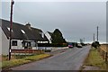
6
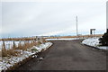
Lochty / Montboy Road at its junction with the road leading to Brechin
Image: © Alan Morrison
Taken: 8 Feb 2009
0.10 miles
7
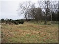
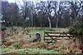
Lochty Wood
The edge of a large wetland wood.
Image: © Richard Webb
Taken: 9 Feb 2013
0.12 miles
8
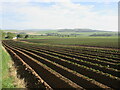
Furrowed field near Lochty
Looking north over a furrowed potato field, with Lochty on the extreme left.
Image: © Scott Cormie
Taken: 30 May 2020
0.13 miles
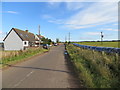
10
Ploughing, Montboy
Preparing land for spring barley.
Image: © Richard Webb
Taken: 9 Feb 2013
0.15 miles