IMAGES TAKEN NEAR TO
Careston, BRECHIN, DD9 6RX
Introduction
This page details the photographs taken nearby to DD9 6RX by members of the Geograph project.
The Geograph project started in 2005 with the aim of publishing, organising and preserving representative images for every square kilometre of Great Britain, Ireland and the Isle of Man.

There are currently over 7.5m images from over14,400 individuals and you can help contribute to the project by visiting https://www.geograph.org.uk
Image Map
Images are licensed for reuse under creativecommons.org/licenses/by-sa/2.0
Notes
- Clicking on the map will re-center to the selected point.
- The higher the marker number, the further away the image location is from the centre of the postcode.
Image Listing (7 Images Found)
Images are licensed for reuse under creativecommons.org/licenses/by-sa/2.0
Image
Details
Distance
2
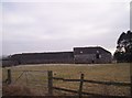
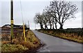
Fields and redeveloped buildings at Montboy
Image: © Steven Brown
Taken: 18 Dec 2012
0.02 miles
3
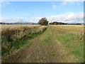
Track between arable fields near to Montboy
Looking north-westward.
Image: © Peter Wood
Taken: 12 Oct 2019
0.13 miles
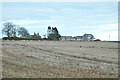
6
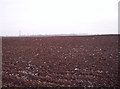
Ploughed Fields
Image: © Dominic Dawn Harry and Jacob Paterson
Taken: 1 Feb 2006
0.21 miles
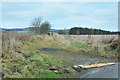
7
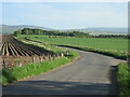
C33 (Angus) Road
The C33 road heading north from Careston towards Menmuir.
Image: © Scott Cormie
Taken: 30 May 2020
0.25 miles