IMAGES TAKEN NEAR TO
Careston, BRECHIN, DD9 6RU
Introduction
This page details the photographs taken nearby to DD9 6RU by members of the Geograph project.
The Geograph project started in 2005 with the aim of publishing, organising and preserving representative images for every square kilometre of Great Britain, Ireland and the Isle of Man.

There are currently over 7.5m images from over14,400 individuals and you can help contribute to the project by visiting https://www.geograph.org.uk
Image Map
Images are licensed for reuse under creativecommons.org/licenses/by-sa/2.0
Notes
- Clicking on the map will re-center to the selected point.
- The higher the marker number, the further away the image location is from the centre of the postcode.
Image Listing (8 Images Found)
Images are licensed for reuse under creativecommons.org/licenses/by-sa/2.0
Image
Details
Distance
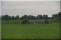
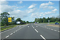
2
Road between the A90 and The Park
Looking north-westward.
Image: © Peter Wood
Taken: 12 Oct 2019
0.14 miles
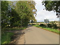
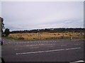
3
Field and strip woodland, Careston
Off the A90.
Image: © JThomas
Taken: 20 Aug 2020
0.16 miles
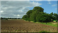
4
Last year's potatoes
A field resting over the Winter at Careston.
Image: © Richard Webb
Taken: 9 Feb 2013
0.18 miles
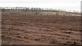
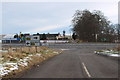
5
Turnoff from the A90 road to Careston
This view is for southbound (locally westbound) motorists on the A90 road.
Image: © C Michael Hogan
Taken: 10 Jun 2011
0.23 miles
6
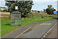
Northbound A90, Careston Road End Bus Stop
Image: © David Dixon
Taken: 19 Sep 2018
0.23 miles
7
View approaching A90 Dual Carriageway at Balnabriech
Image: © Alan Morrison
Taken: 8 Feb 2009
0.23 miles
8
Field of Bales
This is a photo from the Careston junction of the A90 looking
Image: © Dominic Dawn Harry and Jacob Paterson
Taken: 26 Sep 2005
0.24 miles