IMAGES TAKEN NEAR TO
Castle Street, BRECHIN, DD9 6JW
Introduction
This page details the photographs taken nearby to Castle Street, DD9 6JW by members of the Geograph project.
The Geograph project started in 2005 with the aim of publishing, organising and preserving representative images for every square kilometre of Great Britain, Ireland and the Isle of Man.

There are currently over 7.5m images from over14,400 individuals and you can help contribute to the project by visiting https://www.geograph.org.uk
Image Map
Images are licensed for reuse under creativecommons.org/licenses/by-sa/2.0
Notes
- Clicking on the map will re-center to the selected point.
- The higher the marker number, the further away the image location is from the centre of the postcode.
Image Listing (130 Images Found)
Images are licensed for reuse under creativecommons.org/licenses/by-sa/2.0
Image
Details
Distance
1
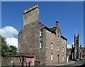
4, 6 and 8 Castle Street, Brechin
Dated 1788 above the oculus and B-listed (LB22429 https://portal.historicenvironment.scot/designation/LB22429 ). Note the gigantic chimney stack. The former Mechanics' Institute can be seen in the background.
Image: © Bill Harrison
Taken: 11 Aug 2023
0.05 miles
3
The Sang Schule
Otherwise known as the Schulie, this was the site of a school first founded in 1429. As the College of Brechin it gave the name to its access lane College Wynd and in the 1580s became the Grammer School. Grammer and Gremmar are old Scots versions of Grammar and the spelling is contemporary to the 16th century. The purple plaque on the wall uses the Grammer form.
Image: © Andrew Wood
Taken: 17 Apr 2010
0.08 miles
4
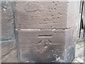
OS Flush Bracket OSBM S4586: Brechin, Former Mechanics Institute
North West face, 0.9m from North East angle of building, South East side of St Marys Street.
Image: © thejackrustles
Taken: 23 Feb 2019
0.08 miles
5
OS Flush Bracket OSBM S4586: Brechin, former Mechanics Institute
North West face, 0.9m from North East angle of building, South East side of St Marys Street.
Image: © thejackrustles
Taken: 23 Feb 2019
0.08 miles
6
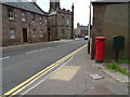
A935, Brechin
Showing position of Postbox No. DD9 47.
See Image] for postbox.
Image: © JThomas
Taken: 11 Jun 2021
0.08 miles
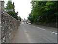
7
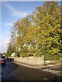
Airlie Street, Brechin
At junction with Argyll Street.
Image: © Stanley Howe
Taken: 27 Oct 2011
0.08 miles
8
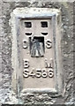
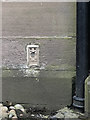
Ordnace Survey Cut Mark
This mark can be found on the wall of Brechin Mechanics Institute. The benchmark height is recorded as being 56.672 metres above sea level.
For more detail see : https://www.bench-marks.org.uk/bm101689
Image: © Peter Wood
Taken: 20 Oct 2018
0.08 miles
9
![Brechin Mechanics Institute [1]](https://s2.geograph.org.uk/geophotos/05/03/10/5031042_a3dbba83_120x120.jpg)
Brechin Mechanics Institute [1]
This delightful Tudor Gothic style building is listed, category B, with details at: http://www.britishlistedbuildings.co.uk/sc-22459-brechin-mechanics-institute-church-street#.V4O1ezU5t8E
Image: © Michael Dibb
Taken: 16 Jun 2016
0.08 miles
10
![Brechin Mechanics Institute [2]](https://s1.geograph.org.uk/geophotos/05/03/10/5031045_6b187ece_120x120.jpg)
Brechin Mechanics Institute [2]
Information about the institute Image
Image: © Michael Dibb
Taken: 16 Jun 2016
0.08 miles