IMAGES TAKEN NEAR TO
Castle Street, BRECHIN, DD9 6JN
Introduction
This page details the photographs taken nearby to Castle Street, DD9 6JN by members of the Geograph project.
The Geograph project started in 2005 with the aim of publishing, organising and preserving representative images for every square kilometre of Great Britain, Ireland and the Isle of Man.

There are currently over 7.5m images from over14,400 individuals and you can help contribute to the project by visiting https://www.geograph.org.uk
Image Map
Images are licensed for reuse under creativecommons.org/licenses/by-sa/2.0
Notes
- Clicking on the map will re-center to the selected point.
- The higher the marker number, the further away the image location is from the centre of the postcode.
Image Listing (135 Images Found)
Images are licensed for reuse under creativecommons.org/licenses/by-sa/2.0
Image
Details
Distance
1
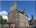
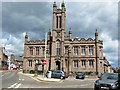
4, 6 and 8 Castle Street, Brechin
Dated 1788 above the oculus and B-listed (LB22429 https://portal.historicenvironment.scot/designation/LB22429 ). Note the gigantic chimney stack. The former Mechanics' Institute can be seen in the background.
Image: © Bill Harrison
Taken: 11 Aug 2023
0.00 miles
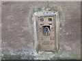
2
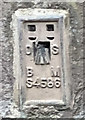
OS Flush Bracket OSBM S4586: Brechin, Former Mechanics Institute
North West face, 0.9m from North East angle of building, South East side of St Marys Street.
Image: © thejackrustles
Taken: 23 Feb 2019
0.03 miles
3
OS Flush Bracket OSBM S4586: Brechin, former Mechanics Institute
North West face, 0.9m from North East angle of building, South East side of St Marys Street.
Image: © thejackrustles
Taken: 23 Feb 2019
0.03 miles
4
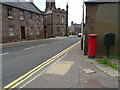
A935, Brechin
Showing position of Postbox No. DD9 47.
See Image] for postbox.
Image: © JThomas
Taken: 11 Jun 2021
0.03 miles
5
Ordnance Survey Flush Bracket S4586
This bracket can be found on the wall of Brechin Mechanics Institute building. The benchmark height is recorded as being 58.451 metres above sea level.
For more detail see : https://www.bench-marks.org.uk/bm10636
Image: © Peter Wood
Taken: 20 Oct 2018
0.03 miles
6
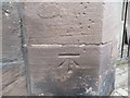
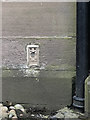
Ordnace Survey Cut Mark
This mark can be found on the wall of Brechin Mechanics Institute. The benchmark height is recorded as being 56.672 metres above sea level.
For more detail see : https://www.bench-marks.org.uk/bm101689
Image: © Peter Wood
Taken: 20 Oct 2018
0.03 miles
7
![Brechin Mechanics Institute [1]](https://s2.geograph.org.uk/geophotos/05/03/10/5031042_a3dbba83_120x120.jpg)
Brechin Mechanics Institute [1]
This delightful Tudor Gothic style building is listed, category B, with details at: http://www.britishlistedbuildings.co.uk/sc-22459-brechin-mechanics-institute-church-street#.V4O1ezU5t8E
Image: © Michael Dibb
Taken: 16 Jun 2016
0.03 miles
8
![Brechin Mechanics Institute [2]](https://s1.geograph.org.uk/geophotos/05/03/10/5031045_6b187ece_120x120.jpg)
Brechin Mechanics Institute [2]
Information about the institute Image
Image: © Michael Dibb
Taken: 16 Jun 2016
0.03 miles
9
Brechin Mechanics' Institute
Brechin Mechanics' Institute opened in 1839, a symmetrical building in the Tudor Gothic style. It was funded by the first Lord Panmure to house schools for local children and to provide informal education for adults. It is a Category B listed building. https://www.britishlistedbuildings.co.uk/200358023-brechin-mechanics-institute-church-street-and-st-mary-street-brechin-and-edzell-ward#.Wy9EcTGWw5s
Image: © G Laird
Taken: 21 Jun 2018
0.03 miles
10
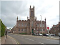
Brechin Mechanics Institute
Completed in 1839, it was gifted to the town by the Dalhousie family and originally housed the Parish, Grammar and Burgh Schools and also provided an Institute for the education of the working men of the district.
Image: © JThomas
Taken: 11 Jun 2021
0.03 miles