IMAGES TAKEN NEAR TO
Kinghorn Place, BRECHIN, DD9 6BT
Introduction
This page details the photographs taken nearby to Kinghorn Place, DD9 6BT by members of the Geograph project.
The Geograph project started in 2005 with the aim of publishing, organising and preserving representative images for every square kilometre of Great Britain, Ireland and the Isle of Man.

There are currently over 7.5m images from over14,400 individuals and you can help contribute to the project by visiting https://www.geograph.org.uk
Image Map (Loading...)


Getting Data...Please wait
Leaflet Map data © OpenStreetMap
Images are licensed for reuse under creativecommons.org/licenses/by-sa/2.0
Notes
- Clicking on the map will re-center to the selected point.
- The higher the marker number, the further away the image location is from the centre of the postcode.
Image Listing (6 Images Found)
Images are licensed for reuse under creativecommons.org/licenses/by-sa/2.0
Image
Details
Distance
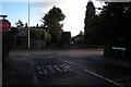
2
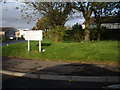
Access to Trinity Fields Crescent, Brechin
From B966.
Image: © Stanley Howe
Taken: 27 Oct 2011
0.19 miles
3
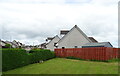
View of Eddie Avenue, Brechin
Picture taken from Trinity Road (B966), looking west.
Image: © Alan Morrison
Taken: 10 Feb 2010
0.19 miles
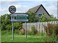
5
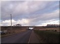
A90 Flyover for Road Between Brechin and Little Brechin
Image: © Dominic Dawn Harry and Jacob Paterson
Taken: 24 Jan 2006
0.23 miles
6
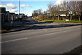
Cookston Crescent, Brechin at its junction with Trinity Road
Image: © Alan Morrison
Taken: 10 Feb 2010
0.25 miles