IMAGES TAKEN NEAR TO
Muirhead Industrial Estate, KIRRIEMUIR, DD8 5QN
Introduction
This page details the photographs taken nearby to Muirhead Industrial Estate, DD8 5QN by members of the Geograph project.
The Geograph project started in 2005 with the aim of publishing, organising and preserving representative images for every square kilometre of Great Britain, Ireland and the Isle of Man.

There are currently over 7.5m images from over14,400 individuals and you can help contribute to the project by visiting https://www.geograph.org.uk
Image Map
Images are licensed for reuse under creativecommons.org/licenses/by-sa/2.0
Notes
- Clicking on the map will re-center to the selected point.
- The higher the marker number, the further away the image location is from the centre of the postcode.
Image Listing (7 Images Found)
Images are licensed for reuse under creativecommons.org/licenses/by-sa/2.0
Image
Details
Distance
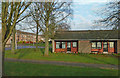
1
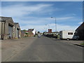
The main road from the south heading in to Kirriemuir
The A928 at what appears to be an area of a little industry.
Image: © James Denham
Taken: 3 Jun 2010
0.04 miles
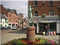
2
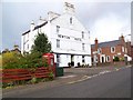
Newton Hotel, Kirriemuir
A small hotel and public house on Glamis Road with a K6 type telephone box beside it.
Image: © Maigheach-gheal
Taken: 7 Oct 2009
0.11 miles
3
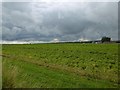
Potato field by Kirriemuir
North Mains of Logie.
Image: © Richard Webb
Taken: 16 Sep 2015
0.18 miles
4
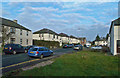
Sidlaw Range View
Houses in Kirriemuir's Sidlaw Range viewed from Lindsay Street.
Image: © Mary and Angus Hogg
Taken: 16 Nov 2018
0.20 miles
5
Isla Road Houses
Viewed from Lindsay Street on a bright November afternoon.
Image: © Mary and Angus Hogg
Taken: 16 Nov 2018
0.23 miles
7
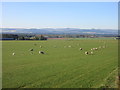
Sheep south of Kirriemuir
Sheep scattered around a field adjacent to the A928 Glamis Road south of Kirriemuir, with the Sidlaw Hills on the horizon.
Image: © Scott Cormie
Taken: 6 May 2020
0.25 miles