IMAGES TAKEN NEAR TO
KIRRIEMUIR, DD8 5QE
Introduction
This page details the photographs taken nearby to DD8 5QE by members of the Geograph project.
The Geograph project started in 2005 with the aim of publishing, organising and preserving representative images for every square kilometre of Great Britain, Ireland and the Isle of Man.

There are currently over 7.5m images from over14,400 individuals and you can help contribute to the project by visiting https://www.geograph.org.uk
Image Map
Images are licensed for reuse under creativecommons.org/licenses/by-sa/2.0
Notes
- Clicking on the map will re-center to the selected point.
- The higher the marker number, the further away the image location is from the centre of the postcode.
Image Listing (4 Images Found)
Images are licensed for reuse under creativecommons.org/licenses/by-sa/2.0
Image
Details
Distance
1

Glasswell near Kirriemuir
A sign has been erected here depicting Glasswell which incorporates Mains of Glasswell Farm and a few houses.
Image: © Alan Morrison
Taken: 4 Jan 2008
0.05 miles
2
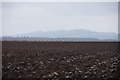
Ploughed field, Glasswell, Kirriemuir
Image: © Mike Pennington
Taken: 12 Apr 2013
0.09 miles
3
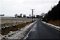
Mains of Glasswell Farm, near Kirriemuir
This picture was taken from Checkiefield which is situated near to the Kirriemuir/Forfar Road.
Image: © Alan Morrison
Taken: 4 Jan 2008
0.13 miles
4
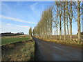
Poplar-lined route
The poplar-lined minor road between the A926 and B957 at Glasswell.
Image: © Scott Cormie
Taken: 28 Dec 2020
0.22 miles