IMAGES TAKEN NEAR TO
Forfar Road, KIRRIEMUIR, DD8 5PT
Introduction
This page details the photographs taken nearby to Forfar Road, DD8 5PT by members of the Geograph project.
The Geograph project started in 2005 with the aim of publishing, organising and preserving representative images for every square kilometre of Great Britain, Ireland and the Isle of Man.

There are currently over 7.5m images from over14,400 individuals and you can help contribute to the project by visiting https://www.geograph.org.uk
Image Map
Images are licensed for reuse under creativecommons.org/licenses/by-sa/2.0
Notes
- Clicking on the map will re-center to the selected point.
- The higher the marker number, the further away the image location is from the centre of the postcode.
Image Listing (9 Images Found)
Images are licensed for reuse under creativecommons.org/licenses/by-sa/2.0
Image
Details
Distance
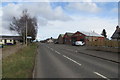
4
Rosewell Road, Maryton, near Kirriemuir
Image: © Mike Pennington
Taken: 12 Apr 2013
0.12 miles
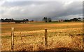
5
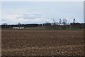
Field off Rosewell Road
Arable land in Strathmore.
Image: © Richard Webb
Taken: 29 Mar 2015
0.19 miles
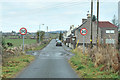
6
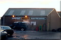
Maryton
It's all go in Maryton!!!!
Image: © Gwen and James Anderson
Taken: 3 Feb 2006
0.20 miles
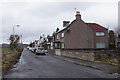
7
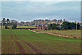
Maryton Farmland View
A November view taken from the A926 looking towards Whitelums.
Image: © Mary and Angus Hogg
Taken: 16 Nov 2018
0.20 miles
9
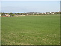
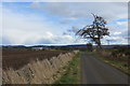
Grassy field near Maryton
Looking westwards over a grassy field towards Maryton and Kirriemuir.
Image: © Scott Cormie
Taken: 4 May 2020
0.23 miles