IMAGES TAKEN NEAR TO
Logie, KIRRIEMUIR, DD8 5PP
Introduction
This page details the photographs taken nearby to DD8 5PP by members of the Geograph project.
The Geograph project started in 2005 with the aim of publishing, organising and preserving representative images for every square kilometre of Great Britain, Ireland and the Isle of Man.

There are currently over 7.5m images from over14,400 individuals and you can help contribute to the project by visiting https://www.geograph.org.uk
Image Map
Images are licensed for reuse under creativecommons.org/licenses/by-sa/2.0
Notes
- Clicking on the map will re-center to the selected point.
- The higher the marker number, the further away the image location is from the centre of the postcode.
Image Listing (7 Images Found)
Images are licensed for reuse under creativecommons.org/licenses/by-sa/2.0
Image
Details
Distance
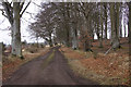
2
Track to Logie
Passing a small triangular beech wood.
Image: © Richard Webb
Taken: 29 Mar 2015
0.09 miles
3
Gorse in bloom by the roadside
Gorse by the side of the minor road between Maryton and Ballindarg.
Image: © Scott Cormie
Taken: 4 May 2020
0.14 miles
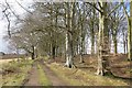
4
Track to Logie
Another casualty of recent high winds, a rather mature beech.
Image: © Richard Webb
Taken: 29 Mar 2015
0.19 miles
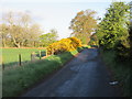
5
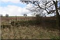
Wall, Rosewell
A roadside enclosure near a small wood.
Image: © Richard Webb
Taken: 29 Mar 2015
0.20 miles
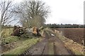
6
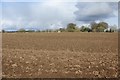
Fletcherfield
Arable land in Strathmore. The railway to Kirriemuir ran under the bridge.
Image: © Richard Webb
Taken: 29 Mar 2015
0.20 miles
7
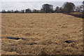
Straw in a field, Rosewell, Kirriemuir
Image: © Mike Pennington
Taken: 12 Apr 2013
0.21 miles