IMAGES TAKEN NEAR TO
Airlie, KIRRIEMUIR, DD8 5PA
Introduction
This page details the photographs taken nearby to DD8 5PA by members of the Geograph project.
The Geograph project started in 2005 with the aim of publishing, organising and preserving representative images for every square kilometre of Great Britain, Ireland and the Isle of Man.

There are currently over 7.5m images from over14,400 individuals and you can help contribute to the project by visiting https://www.geograph.org.uk
Image Map
Images are licensed for reuse under creativecommons.org/licenses/by-sa/2.0
Notes
- Clicking on the map will re-center to the selected point.
- The higher the marker number, the further away the image location is from the centre of the postcode.
Image Listing (6 Images Found)
Images are licensed for reuse under creativecommons.org/licenses/by-sa/2.0
Image
Details
Distance
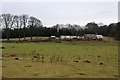
2
Modern stone circle at Philpie
This circle is not marked on maps because it is a modern circle, erected by the landowner within the last few years.
Image: © Mike Pennington
Taken: 30 Dec 2007
0.08 miles
3
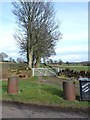
Gateway to Philpie
An imaginative house sign and a pair of recycled oil drums make for a distinctive entrance.
Image: © Oliver Dixon
Taken: 16 Mar 2012
0.08 miles
4

Wooded glen, Airlie
Just visible at the bottom left is a dumped computer (!).
Image: © Mike Pennington
Taken: 2 Jan 2011
0.17 miles
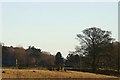
5
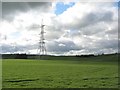
Fields near Airlie, seen from the A926
Image: © David Purchase
Taken: 8 Aug 2012
0.20 miles
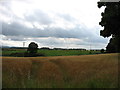
6
Arable land, Philpie
Probably a spring barley crop.
Image: © Richard Webb
Taken: 19 May 2007
0.24 miles