IMAGES TAKEN NEAR TO
KIRRIEMUIR, DD8 5LZ
Introduction
This page details the photographs taken nearby to DD8 5LZ by members of the Geograph project.
The Geograph project started in 2005 with the aim of publishing, organising and preserving representative images for every square kilometre of Great Britain, Ireland and the Isle of Man.

There are currently over 7.5m images from over14,400 individuals and you can help contribute to the project by visiting https://www.geograph.org.uk
Image Map
Images are licensed for reuse under creativecommons.org/licenses/by-sa/2.0
Notes
- Clicking on the map will re-center to the selected point.
- The higher the marker number, the further away the image location is from the centre of the postcode.
Image Listing (5 Images Found)
Images are licensed for reuse under creativecommons.org/licenses/by-sa/2.0
Image
Details
Distance
1
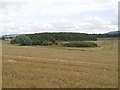
Stubble, Powmyre
Strathmore at harvest time.
Image: © Richard Webb
Taken: 16 Sep 2015
0.12 miles
2
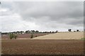
Arable land, Strathmore
Big fields here, mostly stubble covered but a couple here have been ploughed for winter crops.
Image: © Richard Webb
Taken: 16 Sep 2015
0.15 miles
3
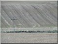
Stubble, Powmyre
View across the Dairsie Burn.
Image: © Richard Webb
Taken: 16 Sep 2015
0.16 miles
4
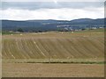
Strathmore arable farming
Stubble fields after the harvest at Powmyre.
Image: © Richard Webb
Taken: 16 Sep 2015
0.16 miles
5
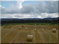
Round bales, Powmyre
The stubble rows show up the contours.
Image: © Richard Webb
Taken: 16 Sep 2015
0.22 miles